Advertisement

The United States Learning Laboratories
The United States Learning Lab is an interactive geography experience that helps students explore all 50 states through maps, challenges, comparisons, and creative activities. Students can investigate states, cities, capitals, national parks, landmarks, landforms, and Native Nations, then use Maptivation to create and customize their own U.S. maps.

United States Learning Lab
Description: The United States Learning Lab is an interactive geography experience that helps students explore all 50 states through maps, challenges, comparisons, and creative activities. Students can investigate states, cities, capitals, national parks, landmarks, landforms, and Native Nations, then use Maptivation to create and customize their own U.S. maps.
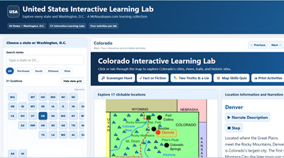
50 States Interactive Map Central - All 50 States in a Single Program
Description: Explore all 50 states and Washington, D.C., with the United States Interactive Learning Labs! This massive collection of 51 interactive state maps allows students to discover hundreds of fascinating cities, historical landmarks, geographic features, and natural wonders through clickable locations, detailed informational passages, photographs, and narration. Each state includes four engaging learning activities: Scavenger Hunt, Fact or Fiction, Two Truths and a Lie, and Map Skills, which challenges students to identify cardinal and intermediate directions using actual map locations. With more than 2,000 questions across the collection, all activities feature online answer checking and printable student worksheets with separate teacher answer keys. Students can explore individual states or use the unified application to navigate the entire country. Featuring updated state statistics, adjustable text sizes, fullscreen functionality, and accessibility features, these Learning Labs are ideal for upper elementary and middle school social studies, geography instruction, independent exploration, classroom centers, and research projects!

United States Regions Learning Lab 2.0
Description: Explore all 50 states with the United States Regions Learning Lab! This comprehensive interactive program features five regional learning labs: New England, Mid-Atlantic, Southern States, Midwest, and Western States. Students can explore clickable maps featuring major cities, mountain ranges, landforms, historical landmarks, and state information. Each region includes narrated informational articles, interactive state identification challenges, randomized 15-question scavenger hunts with printable answer keys, and an advanced Map Creator for coloring, labeling, drawing, and designing customized maps. Special features include regional zoom tools, a Great Lakes Explorer, and selected landmark photographs. Perfect for grades 3–7, this program brings American geography, history, and map skills together in one engaging learning experience!
Advertisement