Advertisement

United States Digital Geography Products
This section contains digital United States interactive maps and games that can be purchased and used with students.

United States Regions Learning Lab 2.0
Description: Explore all 50 states with the United States Regions Learning Lab! This comprehensive interactive program features five regional learning labs: New England, Mid-Atlantic, Southern States, Midwest, and Western States. Students can explore clickable maps featuring major cities, mountain ranges, landforms, historical landmarks, and state information. Each region includes narrated informational articles, interactive state identification challenges, randomized 15-question scavenger hunts with printable answer keys, and an advanced Map Creator for coloring, labeling, drawing, and designing customized maps. Special features include regional zoom tools, a Great Lakes Explorer, and selected landmark photographs. Perfect for grades 3–7, this program brings American geography, history, and map skills together in one engaging learning experience!
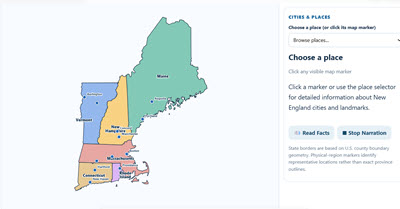
New England Interactive Map and Learning Lab 2.0
Description: Explore the six New England states with this comprehensive interactive geography program! Students can discover important cities, mountain ranges, physical regions, and historical landmarks, including a special zoomable Boston map. Click locations to read detailed information or listen to narrated descriptions. Activities include a Region Challenge, a randomized 15-question online and printable scavenger hunt, and an advanced Map Creator where students can color states, add and move labels, draw, customize, and print their own maps. Perfect for geography, history, and social studies instruction!

Mid-Atlantic States Interactive Map and Learning Lab 2.0
Description: Explore the five Mid-Atlantic states—New York, New Jersey, Pennsylvania, Delaware, and Maryland—with this comprehensive interactive Geography & History Learning Lab! Students can explore clickable maps featuring important cities, mountain ranges, landforms, and historical landmarks, with detailed mini-articles and narration. Special features include a New York City Five Boroughs Explorer, a State Challenge, randomized 15-question online and printable scavenger hunts, and an advanced Map Creator where students can color states, add and move labels, draw, and print customized maps. Perfect for geography, history, and social studies instruction!

Midwestern States Interactive Map and Learning Lab 2.0
Description: Explore the 12 Midwestern states with this comprehensive interactive Geography & History Learning Lab! Students can investigate clickable maps featuring important cities, mountain ranges, landforms, and historical landmarks, with detailed mini-articles and narration. A special Great Lakes Explorer features an accurate, interactive map of all five Great Lakes. Additional activities include Midwest State Quest, a randomized 15-question online and printable scavenger hunt, and an advanced Map Creator where students can color states, add and move labels, draw, and print customized maps. Perfect for geography, history, and social studies instruction!

Southern States Interactive Map and Learning Lab 2.0
Description: Explore the geography and history of the 14 Southern states with this comprehensive interactive Learning Lab! Students can investigate clickable maps featuring important cities, mountain ranges, landforms, and historical landmarks, with detailed mini-articles and narration. Explore state facts and symbols, switch to photographic Landforms View, and zoom into different regions of the South. Activities include a State Challenge, randomized 15-question online and printable scavenger hunts, and an advanced Map Creator where students can color states, add and move labels, draw, and print customized maps. Perfect for geography, history, and social studies instruction!
Western States Interactive Map and Learning Lab 2.0
Description: Explore the geography and history of America's 13 Western states with this comprehensive interactive Learning Lab! Students can investigate clickable maps featuring major cities, mountain ranges, landforms, national parks, and historical landmarks, with detailed mini-articles, photographs of famous landmarks, and narration. Explore state flags and symbols, zoom into different regions, and discover natural wonders such as the Grand Canyon, Yellowstone, Death Valley, and the Rocky Mountains. Activities include Western State Quest, randomized 15-question online and printable scavenger hunts, and an advanced Map Creator where students can color states, add and move labels, draw, and create customized maps. Perfect for geography, history, and social studies instruction!
Advertisement