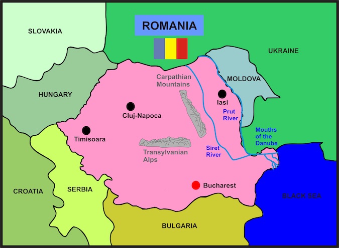
Click on the map below to learn more
 |
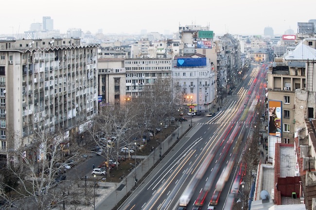
Bucharest, RomaniaBucharest, also known as "The Paris of the East," is the capital and largest city of Romania. It is a vibrant and dynamic city that combines modern elements with historic charm, creating a unique atmosphere that captivates visitors. History and Culture The history of Bucharest dates back to the 15th century, and the city has seen many changes over the centuries. The city's architecture is an excellent representation of its history, with the mixture of styles ranging from the grandiose Belle Èpoque buildings to the Soviet-era apartment blocks. Bucharest has a rich cultural scene, with numerous museums, theaters, and art galleries. The city is home to the National Museum of Art of Romania, which features an extensive collection of Romanian and European art. The Palace of the Parliament, the second-largest administrative building in the world, is also a popular attraction for tourists. The Old Town of Bucharest, also known as Lipscani, is a must-see destination for history enthusiasts. The area is home to many historical landmarks, including the Old Princely Court, the Stavropoleos Church, and the Caru cu Bere restaurant, which has been serving traditional Romanian food since 1879. Food and Drink Romanian cuisine is diverse and flavorful, and Bucharest offers a range of traditional restaurants and modern eateries that serve delicious food. Some of the must-try dishes include sarmale (cabbage rolls stuffed with meat and rice), mici (grilled minced meat rolls), and papanasi (a type of Romanian doughnut). The city also has a thriving coffee culture, and you'll find many coffee shops in the city center. The local specialty is iced coffee, which is perfect for cooling down on a hot summer day. Parks and Recreation Bucharest has several parks and green spaces where visitors can relax and enjoy the outdoors. Herastrau Park, the largest park in the city, is home to a lake, a rose garden, and a Japanese garden. Cismigiu Gardens, located in the city center, is another popular park, with a lake, rowing boats, and a charming cafè. Transportation Bucharest has a reliable public transportation system, which includes buses, trams, and a metro system. Taxis are also readily available, but it's important to use licensed taxis to avoid scams.
|
|
|
|
 |
Timisoara, Romania
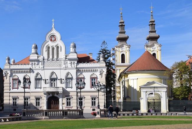
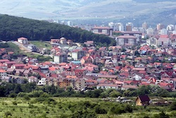
Timisoara is the third-largest city in Romania and the capital of Timis County. It is a vibrant city with a rich history, a diverse cultural scene, and plenty of things to see and do. Located in the western part of Romania, close to the borders with Hungary and Serbia, Timisoara is a perfect destination for those looking to explore a lesser-known corner of Europe. History and Culture Timisoara's history dates back to the Roman Empire, and the city has been shaped by many different cultures and civilizations over the centuries. Timisoara was under Ottoman rule for nearly 160 years before becoming part of the Habsburg Empire in the 18th century. Today, the city's architecture is an excellent representation of its rich history, with buildings influenced by various styles, from Baroque to Art Nouveau. The city has a rich cultural scene, with numerous museums, galleries, and theaters. The Banat Museum, located in the city center, features exhibits on the city's history and culture, while the Museum of the Communist Consumer, located in a former department store, offers a glimpse into the daily life of Romanians during the communist era. Parks and Recreation Timisoara has several parks and green spaces where visitors can relax and enjoy the outdoors. The largest park in the city, the Central Park, is home to a lake, a rose garden, and a Japanese garden. The Children's Park, located in the city center, is another popular park, with a zoo, a playground, and a charming cafe.
|
|
|
|
 |
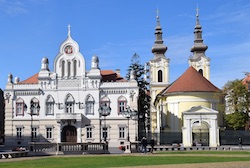
Cluj-Napoca, RomaniaCluj-Napoca is a city located in the northwest region of Romania, with a rich history, stunning architecture, and a vibrant cultural scene. It is the second-largest city in Romania, after Bucharest, and is known for its lively atmosphere and friendly locals. History and Culture Cluj-Napoca has a long and fascinating history, dating back to the Roman Empire. The city was named after the Roman colony of Colonia Aurelia Napoca, and its history can be seen in the ruins of the ancient Roman settlement that still exist in the city. Throughout its history, Cluj-Napoca has been influenced by various cultures, including the Hungarians, Germans, and Austrians, all of which have left their mark on the city's architecture and culture. Today, Cluj-Napoca is a vibrant university town with a lively cultural scene, and it hosts numerous festivals, concerts, and exhibitions throughout the year.
|
|
|
|
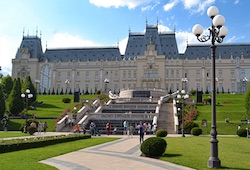 |
Iasi, RomaniaIasi, also known as Jassy, is the largest city in eastern Romania, situated in the region of Moldavia. The city has a rich history and culture, with stunning architecture, vibrant nightlife, and a diverse food scene. Let's take a closer look at what makes Iasi a must-visit destination. History and Culture Iasi has a long and fascinating history, dating back to the 14th century. It was the capital of Moldavia for centuries and played a significant role in the region's history. The city is home to numerous historical landmarks, such as the Palace of Culture, which was built in the early 20th century and houses several museums and galleries. The city is also known for its stunning architecture, with a mix of Gothic, Renaissance, and Baroque styles. The Stavropoleos Monastery, dating back to the 15th century, is one of the city's most impressive landmarks, with its stunning frescoes and intricate carvings. |
|
|
|
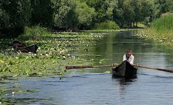 |
The Mouth of the DanubeThe Mouth of the Danube is one of Europe's most important natural landmarks, located in the Danube Delta Biosphere Reserve in Romania. The Danube River is the second-longest river in Europe, flowing through ten countries before emptying into the Black Sea through its delta. The Danube Delta is a unique ecosystem and one of the world's largest wetlands, covering an area of over 4,000 square kilometers. The delta is home to an incredible variety of flora and fauna, with over 5,500 species of plants and animals living within its borders. It is also an important breeding ground for many species of fish and birds, including the endangered white pelican and the Danube sturgeon. The Mouth of the Danube is the final destination of the Danube River before it meets the Black Sea. The river delta fans out into three main channels – Chilia, Sulina, and Sfântu Gheorghe – before eventually merging into a vast network of canals, lakes, and wetlands. The landscape is a breathtaking mix of sandy beaches, wild forests, and serene lagoons, with narrow waterways that weave through the delta like veins. Visitors to the Mouth of the Danube can explore the delta's unique ecosystem on foot, by boat, or on horseback. The area is a paradise for nature lovers and bird watchers, with hundreds of species of birds that can be spotted throughout the year, from the black-winged stilt to the glossy ibis. One of the best ways to experience the Mouth of the Danube is by taking a boat trip along its canals and waterways. The delta's water routes offer stunning views of the surrounding landscape, with opportunities to spot wildlife and explore the local fishing villages. Visitors can also take a trip to the nearby Letea Forest, one of the few remaining primeval forests in Europe, and home to ancient trees and wild horses. The Mouth of the Danube is also a popular destination for fishing enthusiasts, with a variety of species that can be caught in its waters, including carp, pike, and zander. The delta is also famous for its caviar, with the Danube sturgeon providing some of the finest caviar in the world.
|
|
|
|
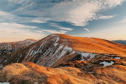
The Transylvanian AlpsThe Transylvanian Alps, also known as the Southern Carpathians, are a stunning mountain range located in central Romania. Stretching over 250 km from the Prahova Valley to the Olt Valley, the Transylvanian Alps offer some of the most spectacular scenery and hiking opportunities in Eastern Europe. The Transylvanian Alps are made up of several distinct massifs, each with its own unique character and attractions. The Bucegi Massif, for example, is home to the famous Sphinx and Babele rock formations, as well as the stunning Peles Castle, a neo-Renaissance palace built in the 19th century. The Fagaras Mountains, on the other hand, are the highest range in the Southern Carpathians, with peaks reaching over 2,500 meters in height. The Fagaras range is home to Romania's highest peak, Moldoveanu, which stands at 2,544 meters above sea level. The Transfagarasan Highway, one of the most scenic drives in the world, passes through the Fagaras Mountains, offering breathtaking views of the surrounding landscape. The Retezat Mountains, located in the southwestern part of the Transylvanian Alps, are a UNESCO Biosphere Reserve and home to over 80 glacial lakes. The area is popular among hikers, with several well-marked trails leading through the mountains and to the summit of Retezat Peak, which stands at 2,509 meters. The Transylvanian Alps offer a range of activities for outdoor enthusiasts, from hiking and camping to skiing and rock climbing. The Piatra Craiului National Park, located in the Carpathian foothills, is a popular destination for rock climbing and mountaineering, with several challenging routes available for experienced climbers. The Transylvanian Alps are also home to a number of charming towns and villages, each with their own unique character and traditions. The town of Bran, for example, is famous for its medieval castle, said to be the inspiration for Bram Stoker's Dracula. The nearby village of Moeciu de Sus is a popular destination for ecotourism, with its picturesque landscapes and traditional way of life.
|
|
|
|
|
 |
The Carpathian MountainsThe Carpathian Mountains are one of Europe's most important mountain ranges, stretching across Central and Eastern Europe. They cover a distance of 1,500 kilometers (932 miles) through seven countries, including Romania, Ukraine, Poland, Slovakia, Hungary, Serbia, and Austria. The Carpathians are an exceptional natural beauty, with their unique flora and fauna, breathtaking landscapes, and a rich history. Geographically, the Carpathian Mountains separate the lowlands of the Danube River from the plains of Ukraine and provide a natural border between Western and Eastern Europe. The Carpathians are divided into three major ranges: the Western Carpathians, the Eastern Carpathians, and the Southern Carpathians. The Western Carpathians, also known as the Czech Carpathians, stretch from Slovakia to the Czech Republic. The Eastern Carpathians, also known as the Ukrainian Carpathians, are located in Ukraine and Romania. The Southern Carpathians, also known as the Transylvanian Alps, are located in Romania. The Carpathians are home to a diverse range of flora and fauna, with more than 13,000 species of plants and animals. The mountains' forests are among the last remaining virgin forests in Europe, and they are home to bears, wolves, lynxes, and many other species of mammals. The Carpathians are also home to a wide variety of bird species, including eagles, owls, and falcons. The Carpathians have been inhabited since prehistoric times, and the mountain range has played an important role in the history of the countries surrounding it. The region has been invaded and settled by numerous tribes and civilizations, including the Celts, the Romans, the Huns, the Mongols, and the Ottomans. The Carpathians were also the scene of many important battles, including the Battle of Kosovo in 1389, which saw the Ottoman Turks defeat the Serbian army. The Carpathians have played an important role in the cultural and economic development of the countries surrounding them. The region is rich in natural resources, including timber, minerals, and water. The Carpathians are also an important source of renewable energy, with many hydroelectric dams located throughout the region. The mountains are also an important destination for tourism, with many ski resorts, hiking trails, and cultural attractions located in the region. |
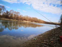 |
Prut RiverThe Prut River is a significant river in Eastern Europe, forming part of the border between Romania and Moldova. It is a tributary of the Danube River and has a length of 953 kilometers, making it the eighth-longest river in Europe. The river flows through picturesque landscapes and is an important waterway for both Romania and Moldova. The Prut River rises in the Carpathian Mountains in Ukraine and flows through Moldova before reaching Romania, where it forms part of the border between the two countries. The river then flows into the Danube River Delta, where it empties into the Black Sea. The Prut River is an important source of water for both Romania and Moldova, providing irrigation for agriculture and supplying water for industrial and domestic use. The river is also an important habitat for fish and other aquatic wildlife, including carp, pike, and sturgeon. The Prut River basin is rich in cultural and historical heritage, with several important landmarks and attractions located along its banks. The city of Iasi, for example, is situated on the banks of the Prut River and is one of Romania's most important cultural centers. The city is home to several historic buildings and museums, including the Palace of Culture and the Metropolitan Cathedral. The Prut River is also home to several picturesque towns and villages, each with their own unique character and traditions. The town of Harlau, for example, is known for its traditional pottery and ceramics, while the village of Cotnari is famous for its vineyards and wine production. The Prut River is also a popular destination for outdoor enthusiasts, with several hiking and cycling trails located along its banks. The river is also popular among fishermen, with several fishing spots located along its length. |
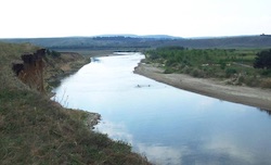 |
Siret RiverThe Siret River is a major river in Eastern Europe, originating in the Carpathian Mountains in Ukraine and flowing through Romania and Moldova before emptying into the Danube River. With a length of 716 kilometers, it is the longest river that flows entirely within Romania. The Siret River is a significant waterway for the region, providing water for agriculture, industry, and domestic use. The river is also an important habitat for fish and other aquatic life, including trout, pike, and sturgeon. The Siret River basin is home to several picturesque landscapes, with the river flowing through dense forests, rolling hills, and fertile valleys. The river is also home to several charming towns and villages, each with their own unique character and traditions. One of the most notable towns along the Siret River is Suceava, located in northeastern Romania. The town is home to several historic buildings and landmarks, including the Suceava Fortress, a medieval castle that served as the capital of Moldavia in the 14th and 15th centuries. The Siret River is also popular among outdoor enthusiasts, with several hiking and cycling trails located along its banks. The river is also a popular destination for fishermen, with several fishing spots located along its length. The Siret River is also significant for its cultural and historical heritage. The river basin is home to several important landmarks and attractions, including several monasteries and churches that date back to the medieval period. One of the most notable attractions along the Siret River is the Painted Monasteries of Bucovina, a UNESCO World Heritage Site located in northeastern Romania. The monasteries are known for their vibrant frescoes and murals, which depict scenes from the Bible and other religious texts. |
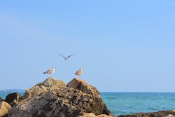 |
Black SeaThe Black Sea is a body of water located between Southeastern Europe and Western Asia. It is connected to the Mediterranean Sea through the Bosporus and Dardanelles straits and is bordered by six countries: Ukraine, Russia, Georgia, Turkey, Bulgaria, and Romania. The Black Sea is the largest inland sea in the world and covers an area of approximately 436,400 square kilometers. It has a maximum depth of 2,212 meters and an average depth of 1,225 meters. The sea's name comes from the dark color of its waters, which is caused by the presence of hydrogen sulfide in the lower depths. Despite its name, the Black Sea is not completely dark, and its waters can appear blue or green in certain conditions. The Black Sea has a rich history, and its shores have been inhabited by many different cultures over the centuries. The ancient Greeks called it the Euxine Sea, and it was an important center of trade and commerce. Later, during the Roman Empire, it was an important military and economic region. The Black Sea has a diverse ecosystem, and its waters are home to many different species of marine life. The sea is known for its sturgeon, which is famous for its roe, also known as caviar. The Black Sea is also home to dolphins, porpoises, and various species of fish. Tourism is an important industry in the Black Sea region, and the sea is a popular destination for beachgoers and water sports enthusiasts. The coastline of the Black Sea is dotted with many resorts and tourist destinations, including the cities of Odessa, Sochi, Varna, and Constanta. Despite its beauty and importance, the Black Sea faces many environmental challenges, including pollution and overfishing. The sea is also vulnerable to oil spills and other environmental disasters, which could have serious consequences for the region's ecosystem and economy. |
Bucharest |
|
| Population: | 19,500,000 (2021) |
| Area: | 92,046 sq. miles |
| Capital City: | Bucharest |
| Largest City: | Bucharest |
| Currency: | Romanian Leu |
| Official Language: | Romania |
| GDP (Gross Domestic Product) | $259.1 Billion (48th) |
| Back to Map | |
Timisoara, Romania
|
|
|
|
 |
|
The Romanian flag is a tricolor flag with three equal vertical stripes: blue, yellow, and red. It was first adopted in its current form in 1989 after the fall of the communist government and the start of the democratic era in Romania. The colors of the flag have different meanings. Blue represents freedom, yellow represents justice, and red represents bravery. These colors were first used during the 1848 revolution when the Romanian people fought for independence from the Ottoman Empire. The flag has undergone many changes throughout history. The earliest recorded use of the Romanian colors was during the Wallachian uprising in 1821. The flag at the time was blue, yellow, and red, but the stripes were horizontal instead of vertical. The horizontal design was used until 1861 when the current vertical design was introduced. During World War II, Romania was an ally of Nazi Germany, and the country's flag included a coat of arms in the center of the yellow stripe. The coat of arms was removed after the communist government took power in 1947, and the flag was changed to have a red star in the center of the yellow stripe. The current design of the Romanian flag was adopted on December 27, 1989, just days after the fall of the communist regime. The new flag had the same colors as before, but without the coat of arms or any other symbols. Back to Map |
|