Click on the map below to learn more
 |
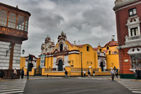
LimaLima is the largest city in Peru and one of the largest cities in the continent of South America. Located near the Andes Mountains, Lima is nicknamed “El Pulpo” (Octopus) for its sprawling suburbs. The city was founded in 1535 by the Spanish conquistador Francisco Pizzaro, who called it the City of Kings. It served as the capital of New Spain in the 17th and 18th centuries and was renowned for its great wealth and magnificence. It is one of the oldest capital cities in South America. In 1746, a major earthquake destroyed Lima. Today, Lima accounts for over one third of the entire population of Peru . It serves as the economic and cultural hub of the nation. Lima has many popular tourist attractions. The entire historic centre of Lima was declared a UNESCO World Heritage Site in 1988 due to its large number of important buildings dating from the Spanish colonial era such as the Plaza Mayor, with its 16th century Cathedral, the Presidential Palace, and the connected catacombs of the Convento de San Francisco, a major monastery built in 1674 that features a world-renowned library. |
| Back to Map | |
 |
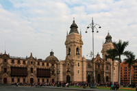
CuzcoCuzco is a city in Peru located in the Andes Mountains. The city was developed and redesigned in the fifteenth century under Incan rule; when the Spanish ruled it in the sixteenth century, many monasteries and manors were built over the Incan heritage. Today, the city’s architecture is a unique blend of Incan culture and colonial rule, featuring a combination of Incan temple ruins and Spanish palaces and churches. It is the seventh most populous city in Peru, and was made a UNESCO world heritage site in 1983. |
| Back to Map | |
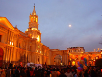 |
ArequipaThe city of Arequipa is nicknamed “La Ciudad Blanca”—the white city—due to its large number of white buildings made of sillar, a volcanic material. The Yanahuara District, a suburb in Arequipa, is particularly renowned for its collection of pearly white sillar-built homes. Snow-capped volcanic peaks are very common in Arequipa, as the city is surrounded by volcanoes that are over 5,000 meters tall. Arequipa is a key commercial city for Peru. One of its chief exports is textiles made from the wool of camelids—members of the camel family. |
| Back to Map | |
 |
TrujilioTrujillo, known as Peru’s City of Eternal Spring, is located on Peru’s northwest coast. It was initially brought to glory by the Moche civilization, who built large structures in the city from 100 AD to 800 AD. The city was ruled by various empires and was often a target for pirates due to its coastal location; therefore, the Wall of Trujillo was built in 1689 as a defense mechanism. The wall was eventually destroyed to allow the city to expand, but pieces of it are still scattered throughout Trujillo. Today, it is one of Peru’s most beautiful colonial cities, but also one of the most dangerous. It contains various historic churches and colonial-era mansions, in addition to archeological sites. |
| Back to Map | |
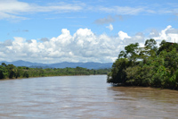 |
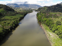
Ucayali RiverThe Ucayali River, a major tributry of the Amazon River, flows north for about 910 miles through Peru. The source of the Ucayali River is located 100 kilometers north of Lake Titcaca. The river has been known as the San Miguel, the Cocama, and the Rio de Cuzco. The Ucayali River is notoriously difficult to navigate. Its rough currents, waterfalls, and reefs, make it particularly dangerous. Large rocks can also fall from the mountains into the river, causing dangerous whirlpools. The Ucayali River is home to a diverse collection of wildlife, including the Amazon river dolphin, the giant otter, and the Amazonian manatee. |
| Back to Map | |
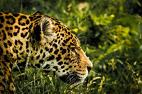 |
Manu National ParkManu National Park is a world-renowned conservation area that is rich with land biodiversity. To this day, the park has no roads and has been largely preserved to avoid human impact and to keep the land untouched for its vast collection of habitats - ranging from lowland rainforests to Andean grasslands. The park is home to between 2,000 and 5,000 different plant species, and over 1,000 vertebrate species, including the giant otter, jaguar, puma, and Andean Mountain Cat. The park was created in 1973, and it was made a UNESCO World Heritage Site in 1987 after first being recognized as a Biosphere Reserve. |
| Back to Map | |
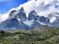 |
AndesThe Andes make up the world’s longest continental mountain range. The range stretches 4,300 miles in length, 430 miles in width, with an average height of about 13,000 feet. The Andes extend through Venezuela, Colombia, Ecuador, Peru, Bolivia, Chile, and Argentina. The mountains are separated into three divisions based on their climate: the Tropical Andes, the Dry Andes, and the Wet Andes. The Andes are part of the American Cordillera, a chain of mountain ranges that make an almost continuous line of mountains that form the western “backbone” of North, Central, South America and Antarctica. |
| Back to Map | |
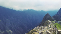 |
Macchu PicchuMachu Picchu is the name for the ruins of a well-preserved Incan city in the Andes Mountains of Peru. The pre-Columbian (before the age of European exploration) city was thought to be built around 1440. It lies at an elevation of 7,711 feet above sea level. Archaeologists believe that Machu Picchu was actually a "resort" town for Incan nobility. It featured a palace, a courtyard, houses, parks, stone stairwells, water fountains and several temples dedicated to Incan Gods. There was even a large astronomical clock known as The Intihuatana. No more than 750 people, however, lived in Machu Picchu at one time. Machu Picchu was actually re-discovered in 1911 by Yale University historian Hiram Bingham III. Today, it is the most famous Incan landmark in the world. Nearly 400,000 people visit the remote ruins every year. |
| Back to Map | |
 |
Amazon RiverThe Amazon River is the second longest river in the world, and is the largest river by volume. It discharges approximately 55 million gallons of water PER SECOND into the Atlantic Ocean. 20 percent of all freshwater that enters the ocean through rivers comes from the Amazon. Its course runs approximately 4,000 miles through South America, much of which is through Brazil. The Amazon holds over 3,000 recognized species of fish, with more still being discovered. |
| Back to Map | |
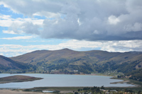 |
Lake TiticacaPeru’s Lake Titcaca, the world’s highest navigable lake, is located at 12,500 feet above sea level in the Andes Mountains. It is South America’s second-largest lake, and is separated into two smaller bodies of water by the Tiquina Strait. Since the lake is located on the border between Peru and Bolivia, its two halves have different names in each country; in Peru, the two smaller bodies are called Lake Pequeño and Lake Grande. The name of the lake roughly translates to Rock of the Puma, or Crag of Lead. Lake Titcaca is home to a large frog that can grow to a foot in length! |
| Back to Map | |
\ |
|
| Macchu Picchu | |
| Population: | 33,105,000 |
| Area: | 496,225 sq. miles |
| Capital City: | Lima |
| Largest City: | Lima |
| Currency: | Sol |
| Official Language: | Spanish |
| GDP (Gross Domestic Product) | $487.4 Billion |
|
|
 |
|
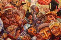
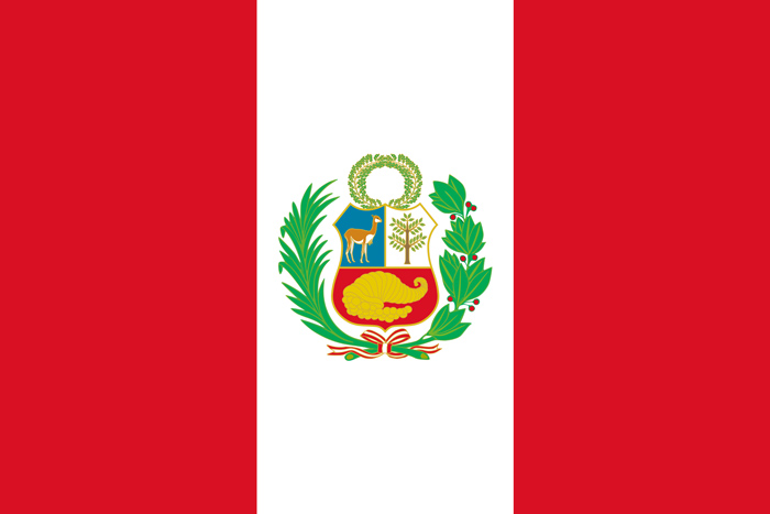
| The red stripes on Peru’s flag represent bloodshed, and the white stripes represent balance and peace. The colors on the flag are also a nod to the native Inca tribes that had a significant role in developing the country. The coat of arms in the center of the flag contains a llama and a chichona tree, both of which are key Peruvian symbols. The round cornucopia in the center represents prosperity. | |