| |
New Mexico - the Land of Enchantment |
| |
|
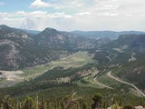
| Click the points of the map below to learn more
|
| |
 |
Albuquerque is the largest city in New Mexico. It was founded in 1706 as a Spanish farming community and military installment on the Real Camino, a network of paths that connected Spanish New World colonies. The village was named after Francisco Fernandez de la Cuerva, Duke of Albuquerque, Viceroy of New Spain from 1653-1660.
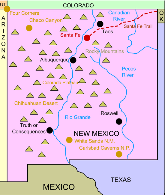
Today, Albuquerque is a rapidly growing city. It is the site of the Albuquerque International Balloon Festival. Over 750 pilots bring their hot air balloons to the festival. More than 100,000 visitors come to see the colorful balloons, the skills and piloting competitions, and the mass launch - when the balloons all go skyward at once.
Back to Map
|
| |
|
 |
Santa Fe
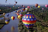
Santa Fe is the capital of New Mexico. It was founded in 1598 as the capital of the province of Nuevo México, an area claimed for Spain by Spanish explorer Francisco Vásquez de Coronado. It is the second oldest settlement in America.
Santa Fe was captured by the U.S. Army in 1846 in the
Mexican-American War. American soldiers used the Santa Fe Trail,
an overland trading route from Missouri to Santa Fe, to invade New Mexico. In 1912, Santa Fe was officially made capital of New Mexico upon its statehood.
Today, Santa Fe is the highest capital city in America
(6,989 ft.). It is home to the Georgia O' Keefe Museum.
Georgia O' Keefe was a famous 20th century painter who
specialized in intricate flowers.
Back to Map |
| |
|
 |
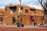
Roswell
Roswell was the site of the infamous 1947 Roswell UFO
Incident. That year, a strange object crashed on a ranch
about 75 miles northwest of the city. The crash was in the
midst of an unprecedented number of UFO sightings in
the western United States. Two days later, the Roswell
Army Airfield reported it had recovered a "flying disc". Almost immediately, the United States Air Force changed the story and reported the object was a weather balloon. Many witnesses of the debris left behind by the "object" disputed the Air Force's claim. Today, there are still many
conspiracy theories regarding what happened at Roswell.
Back to Map |
| |
|
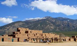 |
Taos
Taos was the site of the 1846 Taos Revolt, an insurrection
by local Mexicans and Indians staged as a protest of American occupation of the region. Many newly appointed government officials were scalped and killed. The insurrection was eventually quelled, and many of the perpetrators were hanged.
Today, Taos is a thriving town that features the homes of Kit Carson and author D.H. Lawrence. It is also the site
of Taos Pueblo, a 1,000 year-old Tiwa town that is still inhabited by about 2,000 people. The main feature of the town is the multi-storied adobe dwelling that is divided into two
parts by the Rio Pueblo. About 150 people live there.
Back to Map |
| |
|
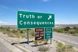 |
Truth or Consequences
Known throughout New Mexico as "T or C," the town of
Truth or Consequences got its name from the popular 1950's
radio show. The host of the show, Ralph Edwards, announced that he would broadcast the program from the first town that agreed to rename itself after the show.
The town, originally called Hot Springs, for its naturally
hot mineral baths, saw an opportunity to market itself
to the entire nation. The residents overwhelmingly voted to change the town's name to Truth or Consequences. Until his death in 2005, Edwards returned to the town every year in honor of its name change.
Back to Map |
| |
|
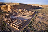 |
Chaco Canyon
Chaco Canyon contains some of the world's most
fascinating and mysterious Pueblo Indian architectural
samples. The canyon is the site of dozens of Pueblo buildings, most of which are thought to be astronomically designed and connected to specific movements of the sun or moon. The area was likely the cultural, spiritual, and trading hub of the Pueblo people, though scientists believe that few people lived there.
Pueblo Bonita is the largest of all of the buildings. It covers two acres and features 650 rooms. Part of the building is four stories high.
Back to Map |
| |
|
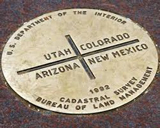 |
Four Corners
Four Corners is an area of the American southwest, in
which the states of Utah, Colorado, Arizona, and New
Mexico all meet. Visitors can position themselves to be in all four states at one time. It is the only place in America
where four states meet.
Back to Map |
| |
|
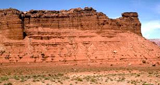 |
Colorado Plateau
The Colorado Plateau is a large 130,000 square mile
plateau centered on the Four Corners region of the American southwest. A plateau is a relatively flat area of high
land. The semi-arid region features remarkable rock
formation such as cliffs, arches, canyons, natural bridges and monoliths. Precipitation that falls in the area is drained to the sea by the Colorado River. The region is home to nine National Parks including Grand Canyon, Arches, and Zion.
Back to Map |
| |
|
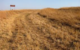 |
Santa Fe Trail
The Santa Fe Trail was an historic trail from central Missouri to Santa Fe, New Mexico used in the 1800's for trade and military purposes. After the United States acquired the southwest following the Mexican-Americn War, the trail helped open the region to residential and commerical development. Today, the route is commemorated as the Santa Fe National Historic Trail.
Back to Map |
| |
|
 |
Pecos River
| Length: |
926 miles |
| Source: |
Mora County, NM |
| Outflow: |
Rio Grande |
| |
|
Back to Map |
| |
|
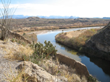 |
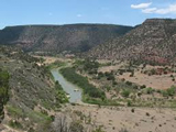
Rio Grande
| Length: |
1,900 miles (4th longest in USA) |
| Source: |
San Juan County, CO |
| Outflow: |
Gulf of Mexico |
| |
|
| The Rio Grande, which forms the entire Mexico-Texas border, is called the Rio Bravo in Mexico. Scientists fear that the river could dry up in the future if rainfall levels fail to increase and populations near the river continue to rise. |
Back to Map |
| |
|
 |
Canadian River
| Length: |
760 Miles |
| Source: |
Southwestern Colorado |
| Outflow: |
Arkansas River |
| |
|
The Canadian River is the largest tributary of the Arkan-
sas River. While it can carry large volumes of water after
storms, it is often just a small stream surrounded by mud
flats and quicksand. |
Back to Map |
| |
|
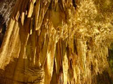 |
Carlsbad Caverns National Park
Carlsbad Caverns, located in southern New Mexico, features
over 100 caves, including Lechaguilla, the nation's deepest limestone cave (1,567 feet). Lechaguilla holds formations and microbes found nowhere else in the world. Carlsbad Caverns is also home to a famous, massive colony of hundreds of thousands of Mexican free-tailed bats.
Back to Map |
| |
|
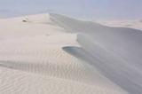 |
White Sands National Monument
White Sands National Monument is an area of the Tularosa
Basin in southern New Mexico that features a 275 square
mile field of white sand with gypsum crystals. Gypsum in the form of sand is extremely rare because it is water soluable and is usually dissolved by water and carried into the sea. However, because the Tularosa Basin has no
outlet to the sea, the gypsum remains trapped in the sand
and sinks to the ground or forms shallow pools that dry out, leaving the gypsum in a crystalline form called selenite
on the surface. Because the gypsum in the sand does not trap heat, visitors can walk on the surface
without burning their feet.
Back to Map |
| |
|
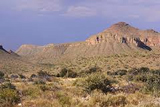 |
Chihuahuan Desert
The Chihuahuan Desert is an arid region that covers parts of western Texas, southern New Mexico, and northerm Mexico. Because it lies at a higher altitude than the nearby Sonoran desert, the climate is slightly milder, although summer temperatures often top 110 degrees Fahrenheit. The region includes numerous basins and sub-ranges of the Rocky Mountains including the Guadalupe and Sacramento. It also includes Big Bend and Carlsbad Caverns National Parks.
Back to Map |
| |
|
 |
Rocky Mountains
The Rocky Mountains extend for about 2,000 miles from
British Columbia to New Mexico. They are called the
Sacramento, Sangre de Cristo, Zuni and San Andreas Moun-
tains in New Mexico.
Highest Point:
|
Mt. Elbert (CO) 14,433 ft |
| Highest Point in New Mexico: |
Wheeler Peak (13,161 ft.) |
| |
|
|
| |
|
|
| State Bird |
| |

New Mexico State Bird: Roadrunner |
| |
| Top Five Facts |
| |
1. ) At over 7,000 feet in elevation, Santa Fe is the nation's highest capital city. It is also the nation's oldest capital city, founded in 1610. |
2. ) The Microsoft Corporation was actually founded by Bill Gates and Paul Allen in Albuquerque, New Mexico. |
3. ) In 1945, the world's first detonation of a nuclear weapon occurred was conducted at the White Sands Proving Ground in New Mexico. |
4. ) New Mexico is the only state to have a state question. It's question is "red or green?" |
5. ) New Mexico boasts more Ph.D.s per capita than any other state. |
| |
| New Mexico in History |
| |
|
1540-1542: Francisco Vazquez de Coronado explores New Mexico searching for the Fabled Seven Cities of Cibola.
1598: Juan de Oñate establishes the first Spanish settlement in New Mexico and directs the building of El Camino Real (Royal Road) from Mexico to modern day New Mexico. That same year, the settlement of Santa Fe was founded. It is the nation's second oldest permanent settlement.
1680: Pueblo Indians revolt against the Spanish presence in the area and succeed in driving them away.
1692: Spanish military forces reclaim the region.
1807: American Zebulon Pike explores the region and visits Santa Fe.
1821-1846: Settlers along the Santa Fe Trail begin to descend upon modern-day New Mexico. The 1846 Taos Revolt, staged by local Indians, resulted in the scalping ofseveral newly appointed American officials in the region.
1828-1840: Kit Carson and John C. Fremont explore parts of New Mexico. Carson sets up headquarters in Taos from which he makes plans to remove Indians from the region.
1850: The New Mexico Territory is formed as a result of the Compromise of 1850. The area originally included Arizona, New Mexico, and parts of Colorado.
1853: The U.S. Government acquires the rest of New Mexico in the Gadsden Purchase.
1862: Union forces defeat the Confederates at the Battle of Glorietta Pass. The largest battle to have occurred in New Mexico, it is sometimes referred to as "the Gettysburg of the West."
1880: Railroads reach Santa Fe and Albuquerque spurring considerable growth.
1880: The great cattle boom in New Mexico establishes it as a ranching center. Conflicting land claims result in bitter feuds and the birth of outlaw legends such as Billy the Kid.
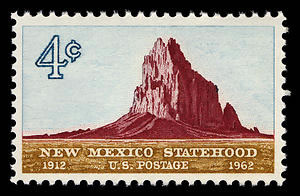
1912: New Mexico is admitted as the 47th state.
1943: U.S. government develops nuclear weapons at the Los Alamos Research Center. The first bombs are tested near Alamogordo.
1947: U.F.O. claims are first made near Roswell.
|
|
|