Click the points on the map to learn more.
 |
New DelhiNew Delhi is the capital of India. It was constructed between 1912-1929 to replace Calcutta as the capital of British India. It was officially made capital in 1931. The city holds numerous historic monuments and temples, including many temples once frequented by Mahatma Gandhi. As a major administrative center and transportation hub, in recent years New Delhi has experienced overcrowding and severe air pollution. New Delhi is the capital district within the sprawling city of Delhi. Delhi's population has spiraled to over 20 million people. |
| Back to Map | |
 |
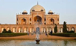
MumbaiThe city of Mumbai, located on the west coast of India, was known as Bombay until 1995. It’s a port city, and one of India’s dominant urban centers. Mumbai was the main western gateway for the expansion of Britain’s Indian empire, and today is India’s commercial and financial capital. It is one of the largest and most densely populated cities in the world, with a population of almost 18 million. Mumbai's Bollywood serves as the film capital of India and the largest film industry center in the world. Mumbai is one of the most heavily polluted cities in the world - breathing the air for just one day is equivalent to smoking 100 cigarettes. |
| Back to Map | |
 |
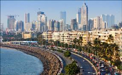
KolkataOriginally founded as trading post of the British East India Company, Calcutta (Kolkata) was the capital of British India from 1833 - 1912. Today, it is the capital of the Indian state of West Bengal. It is the second largest city in India and industrial center of eastern India. Although the city suffered a period of economic stagnation after India gained its independence in 1947, it has returned to prominence. It is home to the Calcutta Stock Exchange, the second most important in India, and many major corporations. It is a major center of regional banking and IT (Information Technology) services. Calcutta, known as "the City of Palaces," is rich in culture and history. The Indian Museum, which features exhibits on Indian natural history and Indian art, is the oldest museum in Asia. |
| Back to Map | |
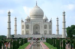 |
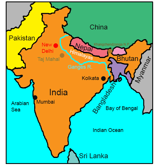
Taj MahalThe Taj Mahal is a colossal palace and complex located in Agra, India. It was constructed between 1631 and 1654 and took 22,000 workers to complete. According to legend, Mughal Emperor Shah Jahan had the palace built for his favorite wife Mumtaz after she died giving birth. Both the emperor and Mumtaz are entombed within the Taj Mahal’s burial chamber. The Taj Mahal is famous for its marble construction. Today, the Taj Mahal is considered the finest example of Mughal architecture (A combination of Persian, Indian and Islamic styles) in existance. The palace itself is characterized by its giant marble dome that surmounts the tomb site. The dome alone, along with its spire, is about 100 feet tall. |
| Back to Map | |
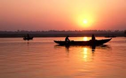 |
Ganges RiverThe Ganges River begins in the Himalayas, and flows across India and Bangladesh into the Bay of Bengal. It is 1,569 miles long, and the world’s third largest river by discharge. In Hinduism, the Ganges is considered the most sacred river, worshipped as the Goddess Ganga. Largely because of industrial and human waste, it was declared the 5th most polluted river in the world in 2007. This pollution threatens more than 200 species of amphibians and fish, as well as the humans who rely on the river for water. |
| Back to Map | |
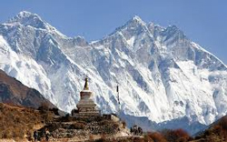 |
HimalayasThe Himalayas pass through India, Pakistan, Afghanistan, China, Bhutan, and Nepal. The range is made up of three parallel ranges referred to as the Greater Himalayas, the Lesser Himalayas, and the Outer Himalayas. The Himalayas are rich in biodiversity, from tropical climates at the base of the mountains, to permanent snow and ice at the highest elevations. The mountain range is home to Mount Everest, as well as the source of three major river systems in Asia. The mountains hold the third largest deposit of ice and snow in the world and feature more than 100 mountains exceeding 22,800 feet in height. The word "Himalayas" is Sanskrit for ‘abode of snow,’ |
| Back to Map | |
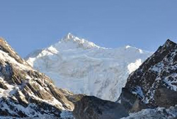 |
Khangchendzonga National ParkKhangchendzonga National Park is located in the heart of the Himalayan range in northern India, in the State of Sikkim. It includes a variety of plains, valleys, lakes, glaciers, forests, and snow-capped mountains. The world’s third highest peak, Kangchenjunga, is located in the park. The indigenous people of Sikkim worship a number of natural elements found in the park, many of which are the subjects of mythological stories with sacred meanings. |
| Population: | 1.252 billion |
| Area: | 1,269,000 square miles |
| Capital City: | New Delhi |
| Largest City: | Mumbai |
| Currency: | Indian Rupee |
| Official Language: | Hindi; English |
| GDP (Gross Domestic Product) | $1.877 trillion |
- India became an independent nation in 1947
- India is the world's largest democracy
- 13 of the 20 most polluted cities in the world are in India
- In the 19th century Great Britain was the dominant political power in India; the British Indian Army played a vital role in both World Wars
- India’s official emblem is the Lion Capital of Ashoka, depicting four Asiatic lions standing back to back on an elaborate base
- Cricket is the most popular sport in India
- India is expected to be the world’s most populous country by 2050
- 70% of all the world’s spices come from India
- India’s Hindu calendar includes six seasons - spring, summer, monsoon, autumn, winter, and preverbal
- India’s national animal and symbol is the endangered Bengal tiger |
|
 |
|
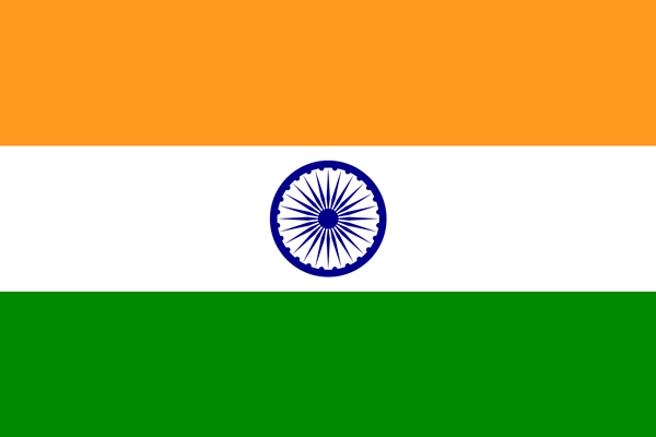
The saffron (subdued orange) band represents courage, sacrifice, and the spirit of renunciation; the white band represents purity and truth, and the green symbolizes faith and fertility. The blue chakra (24-spoke wheel) symbolizes the wheel of life in movement and death in stagnation. |
|