Click the points on the map to learn more.
 |
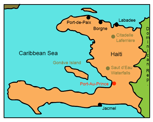
Port-Au-PrincePort-au-Prince, Haiti’s capital and largest city, is located on the natural harbor of the Gulf of Gonâve. Its location has allowed it to sustain more economic prosperity than any other area of Haiti, as an export center for the country. The city has frequently suffered from fires, civil strife, and earthquakes - most recently the 2010 magnitude 7.0 earthquake that left hundreds of thousands dead and over a million homeless, and rendered the city mostly destroyed. The city is still working to rebuild. |
| Back to Map | |
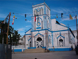 |
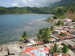
Port-de-PaixLocated on Haiti's northern coast, Port-de-Paix, is one of the largest communes in Haiti. A commune is onsidered a third-level district in Haiti, roughly equivalent to an American city. Christopher Columbus landed near the city in December of 1492 and named it Valparaíso, but the commune wasn't formally founded until 1665. In 1802, a fire totally destroyed Port-de-Paix. Today, the Port-de-Paix is extremely poor. Most of its economy is based on agriculture. Sadly, there is a sense among the people of the commune that they have been forgotten by the Haitian government. |
| Back to Map | |
 |
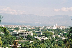
JacmelFounded by the Spanish in 1504, Jacmel was repopulated by the French in 1698. Today, Jacmel featured well-preserved historical French colonial architecture, dating back from the early 19th century. In 1925, Jacmel was the first city in the Caribbean to have electricity, and therefore was nicknamed “City of Light.” The town is known as the handicrafts capital of Haiti, with many tourists coming to see and buy the artisans’ hand-painted souvenirs. |
| Back to Map | |
 |
BorgneBorgne is an agricultural and fishing community on Haiti’s northern peninsula. The people of the Borgne are very poor and many live on less than $1.00 per day. Houses are without electricity, running water, or telephone service. Le Borgne is the capital of the commune, and is both the largest settlement and the administrative hub of the commune. |
| Back to Map | |
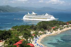 |
LabadeeLabadee is a port on Haiti's northern coast that has been leased to Royal Caribbean International until 2050. The cruise line uses the port as a stop on their Caribbean cruises, and has provided a significant boost to the economy of the area and Haiti in general. RCI has contributed employment to hundreds of locals, as well as paying the government for each tourist they bring, and in the wake of the 2010 earthquake, provided over $1 million worth of assistance and supplies that they brought to the country through the port. |
| Back to Map | |
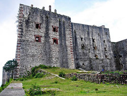 |
Citadelle LaferrièreCitadelle Laferrière is large mountaintop fortress located in northern Haiti. The citadel was built in the early 19th century following Haitian independence to defend against a possible second invasion by the French. As many as 20,000 Haitians were thought to have helped build the massive fortress. Because the French failed to return to Haiti, the fortress was never used, but remains the largest fortress in the Western Hemisphere. Citadel Laferrière was chosen as a UNESCO World Heritage Site in 1982. |
| Back to Map | |
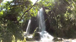 |
Saut-d'Eau WaterfallsThe waterfalls are located about 60 miles north of Port-au-Prince. The falls became a notable site and sacred area after it ws reported that the Virgin Mary had appeared on a nearby palm tree. Every year, thousands go on religious pilgrimage to the falls and bath in the waters, praying to Mary to heal from their ailments. |
| Population: | 10,312,000 |
| Area: | 10,713 square miles |
| Capital City: | Port-au-Prince |
| Largest City: | Port-au-Prince |
| Currency: | Haitian Gourde |
| Official Language: | French; Haitian Creole |
| GDP (Gross Domestic Product) | $8.6 billion |
- Haiti is the poorest country in the Western Hemisphere
- In January 2010, the worst earthquake in 200 years (magnitude 7.0) hit 15 miles west of Port-au-Prince, killing over 300,000 and leaving some 1.5 million homeless
- Haiti was the first Caribbean state to achieve independence
- In 1904, Haiti became the first post-colonial Black-led nation in the world
- Haiti’s national flower is the hibiscus
- Haiti occupies one-third of the island of Hispaniola, sharing the island with the Dominican Republic
- The country’s native Taino name means “land of high mountains,” and was originally applied to the entire island of Hispaniola
- Voodoo was recognized as an official religion in the nation in 2003
- The country is split between the Creole-speaking Black majority, and the French-speaking people of mixed African and European descent
- In what came to be known as the Haitian Revolution, Haiti's slaves revolted against their French rulers, eventually defeating Napoleon Boneparte's army and achieving independence in 1804. Haitian independence had a significant impact on American history as it was one of the reason's Napoleon chose to sell the Louisiana Territory to the United States
|
|
 |
|
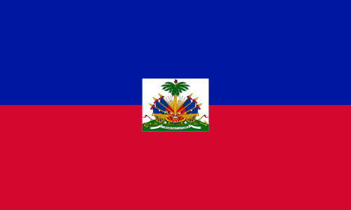
The blue and red colors are taken from the French flag, and represent the union of Black and European people. The white rectangle holds the coat of arms, including a palm tree flanked by flags, and two cannons above a scroll reading L’UNION FAIT LA FORCE (“Union Makes Strength”). |
|