Located at the junction of the Great Plains and Rocky Mountains, Denver is the largest city in Colorado. Originally called Montana City, Denver was named after Kansas Territory governor James W. Denver.
The city was incorporated in 1861 and became capital of the Colo-rado Territory in 1865. Today, Denver is a thriving city. It is home to many major corporations such as Coors, Quizno's, and Frontier Airlines. It is called "The Mile High City" because its altitude is 5,280 feet above sea level.
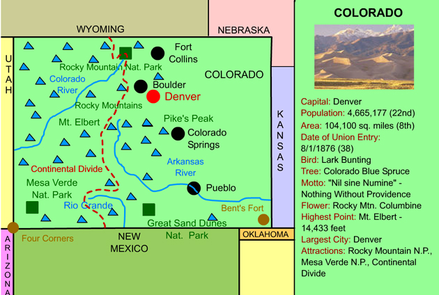
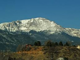
Located some 6,035 feet above sea level, at the base of Pike's Peak, Colorado Springs is the second largest city in Colorado. Colorado Springs was founded by General William Palmer as a resort town. Much of the city, however, was built by Winfield Scott Stratton, who discovered one of the richest gold mines in history at nearby Cripple Creek.
In 1954, president Dwight D.Eisenhower authorized construction of the U.S. Air Force Academy in Colorado Springs.
Did you know the famous song America the Beautiful was written here?
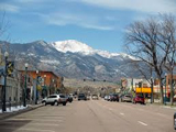
Pueblo was founded soon after the Colorado Gold Rush of 1859 at the junction of the Arkansas River and Fountain Creek. It became a major center of steel production and was the site of the Colorado Fuel and Iron steel mill. In 1921, however, a major flood crippled Pueblo. Over 1/3 of all businesses in the city were lost.
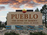
Fort Collins was founded as a United States military outpost in 1864. It was incorporated in 1874 and named after William O. Collins, a commandant at Fort Laramie in Wyoming. Four years earlier, in 1870, Colorado State University was chartered in Fort Collins. The town of Fort Collins was once known as the "lamb feeding capital of the world" because of the abundance of beets grown in the area. The tops of the beets provided good feed for sheep.
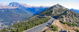
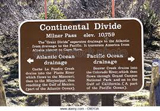
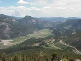
Positioned on the Continental Divide, at the headwaters of the mighty Colorado River, Rocky Mountain National Park is a spectacular celebration of the Rocky Mountains. The park features dazzling views of the towering peaks and is full of wildlife including black bears, moose, mountain lions, and elk.
Trail Ridge Road, in the heart of the park, ascends to over 12,000 feet above sea level. It is the highest paved road in the United States.
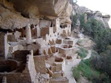
Mesa Verde National Park, located in southwestern Colorado, features unparelleled views into pre-colonization America. From 600 to 1300 AD, the park was home to ancient Puebloan people who built cliff dwellings (houses built into shallow caves in the canyon walls). One of the dwellings, known as Cliff Palace, is the largest cliff dwelling in NorthAmerica. It contains over 150 rooms, which indicated 100 to 120 people lived in it.
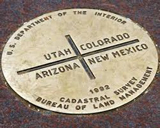
Four Corners is an area of the American southwest, in which the states of Utah, Colorado, Arizona, and New Mexico all meet. Visitors can position themselves to be in all four states at one time. It is the only place in America where four states meet.
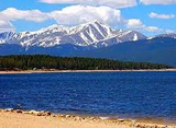
At 14,433 feet above sea level, Mt. Elbert is the highest mountain in the Rocky Mountains, and the second highest mountain in the lower 48 states. Mt. Elbert was named after Samuel Elbert in 1873, a controversial governor of the Colorado Territory. Despite its massive size, most mountain climbers report that climbing Mt. Elbert is not especially difficult.
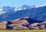
Great Sand Dunes National Park and Preserve, located in
southern Colorado, is one of our newest national parks. The park features the nation's highest sand dunes - towering 750 feet against the Sangre de Cristo Mountains. The dunes are spectacular, and even contain creeks that flow on top of the sand. Great Sand Dunes National Park and Preserve also features a variety of wildlife, and several insect species found nowhere else on earth.
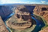
The mighty Colorado River, which eventually flows through several national parks before carving the Grand Canyon, starts as a narrow stream near Lake Granby in Colorado's Rocky Mountain National Park.
The Arkansas River is the 5th longest river in the United
States. Ports on the river include Wichita, Kansas; Tulsa,
Oklahoma; and Little Rock, Arkansas.
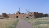
Bent's Fort was a major trading post and resting stop along the Santa Fe Trail. Because the fort was the only White settlement on the Santa Fe Trail, it served explorers, adventurers, and the U.S. Army as a place to get needed supplies, wagon repairs, livestock, food, water, rest, and protection from the Native Americans. In 1849, the fort was destroyed. Some researches believe it was attacked by natives, while others believe it was blown up by the Bent Brothers after a failed attempt to sell it to the U.S. Army.
Pike's Peak (14,110 ft.) is the most visited mountain in North America, and the second most visited in the world. The peak itself is the easternmost high peak in the Rockies. It came to symbolize the gold rush of 1859. It was named after Zebulon Pike, who surveyed the area after the Louisiana Purchase
(1806).
The Continental Divide is a line that forms the border between the watersheds of the Atlantic Ocean and the Pacific Ocean. In other words, waterways that occur west of the divide flow out (eventually) to the Pacific Ocean, and waterways that fall east of the line flow out (eventually) to the Atlantic Ocean. Therefore, rain or snow that falls west of the divide can be expected to end up in the Pacific Ocean and rain or snow that falls east of the divide can be expected to end up in the Atlantic Ocean.
Boulder, originally named Boulder City, was named for the rock formations that rise on the western portion of town known as the Flatirons. Boulder was originally a supply post for miners looking for gold in the nearby mountains.The city was incorporated in 1873.
Boulder has always been the center of education in Colorado. Colorado's first school opened there in 1860. In 1877, the University of Colorado opened in Boulder.
The legendary Rocky Mountains extend through much of western North America from Canada to New Mexico. The "Rockies," as they are often called, stretch over
2,000 miles.
1. ) America the Beautiful was written by Kathy Lee Bates at the top of Pike's Peak in Colorado Springs.
2. ) The 13th step at the state capitol building in Denver is exactly one mile in altitude above sea level. This is why Denver is called the Mile High City.
3. ) The world's first rodeo was held on July 4, 1869, in Deer Trail, Colorado.
4. ) Denver, Colorado is the only city to turn down an invitation to host the Winter Olympics (which it did in 1976).
5. ) Leadville, Colorado, at 10,430 feet above sea level, is the nation's highest incorporated city.
1540-1542: Francisco Vazquez de Coronado explores Colorado searching for the Fabled Seven Cities of Cibola.
1803: The United States purchased what is now most of eastern Colorado from France. Napoleon Bonaparte acquired this land from Spain in 1800 and sold it to the United States in 1803 as a part of the Louisiana Purchase, which was signed by President Thomas Jefferson.
1859: A large number of settlers came to Colorado, creating areas such as Boulder and Denver, during The Colorado Gold Rush of 1859. This is considered the largest gold rush in American history.
1861: Congress chose the name "Colorado" for the territory that is now the state of Colorado. It was named after the red color of the Colorado River. The word Colorado is of Spanish origin and means "colored red".
1870: The Denver and Pacific Railroad was made to connect Denver to the Union Pacific Railroad at Cheyenne, Wyoming.
1876: Colorado became the 38th state. It is called the Centennial State because it was admitted to the Union one hundred years after the signing of the Declaration of Independence.
1893: The right to vote was granted to Colorado women on November 7.
1894: The capital, Denver, was completed.
1905: Believe it or not, the State of Colorado had three Governors in one day: Alva Adams, James H. Peabody, and Jesse F. Macdonald.
1913: The Big Snow of 1913 covered Colorado in snow up to 3-5 feet.
1943: The last Grey Wolf in Colorado died.
1958: The United States Air Force Academy was built close to Colorado Springs.
1972: Colorado was granted and rejected the award to host the 1976 Winter Olympics. Colorado is the only state to ever reject the award as the site of the olympics. The 1976 Winter Olympics were relocated to Innsbruck, Austria.
1999: Two gunman storm Columbine High School and systematically kill 15 people, including themselves.