Click on the map below to learn more
 |
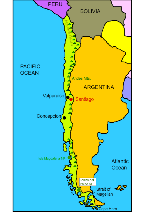
SantiagoSantiago is the capital city of Chile, named for the biblical figure St. James. The city was founded in 1541 by Pedro de Valdivia, a Spanish conqueror. With a population of over seven million people, the Santiago Metropolitan Region is Chile’s largest and most densely-populated area in Chile. Santiago is also the cultural, political, and economic center of Chile, and many multinational corporations have established their headquarters there. Some of Chile’s most successful football clubs are based in Chile, including Colo-Colo, which has won 30 national titles and 10 Copa Chile wins. |
| Back to Map | |
 |
ConcepciònConcepciòn is located in south-central Chile, near the Biobio River. The city’s proximity to Concepciòn Bay and the pathway to the Central Valley provided by the Biobio River make it a prime commercial and industrial center for the country. It is the nation's second largest city. The location of the city was shifted to its current one in the 1800s due to a series of earthquakes and tsunamis that affected the area from the 1500s to the 1700s. In 2010, an 8.8 magnitude earthquake crippled the city, leaving 521 people dead and thousands injured. The earthquake moved the city three meters to the west. Luckily, the tsunami that followed missed Concepciòn. Concepciòn is known as the capital of Chilean rock; many rock bands got their start in the city, including Los Tres and Los Bunkers. It is also known as the university city, due to the large number of universities present. |
| Back to Map | |
 |
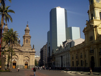
ValparaisoValparaiso is a city and seaport, and the third largest metropolitan area in Chile. In the nineteenth century, it served as a major stopping point for ships crossing the Straits of Magellan to go between the Atlantic and Pacific Oceans. European immigrants were also attracted to the city during its golden age, as it was known as “Little San Francisco” and “The Jewel of the Pacific.” The city is home to Latin America’s oldest stock exchange, Chile’s first volunteer fire department, and Chile’s first public library. The oldest Spanish-language newspaper still in publication around the world, El Mercurio de Valparaiso, is based out of the city as well. |
| Back to Map | |
 |
Cape HornCape Horn is a piece of land located on Hornos Island in Southern Chile. It was discovered by Dutch sailors in 1616. The Atlantic, Pacific, and Southern Oceans all meet at Cape Horn, causing the waters surrounding it to have treacherous, stormy conditions including strong winds and waves as high as ten-story buildings. The sailing route around Cape Horn was a crucial passageway for international trade, especially in the 1800s. Between the sixteenth and twentieth centuries, at least 800 shipwrecks were recorded along Cape Horn. Today, the Cape Horn Monument, built in 1992, honors those who lost their lives trying to cross the path through Cape Horn. The monument itself features an artistic depiction of an albatross in flight. An albatross is a sea bird that typically flies tens of thousnds of miles on the open ocean in its lifetime |
| Back to Map | |
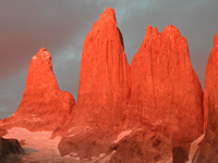 |
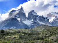
Torres del Paine National ParkTorres del Paine National Park in southern Chile features mountains, glaciers, and lakes. The center of the park is the Cordillera Paine, a group of mountains that connects the subpolar forests and Patagonian Desert. The park is one of the largest and most-visited in Chile, and averages over 250,000 visitors a year, over half of which are foreign tourists. The park is named for three granite mountain peaks from the Paine mountain range that rise up to 2,500 meters above sea level. |
| Back to Map | |
 |
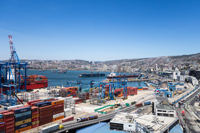
Isla Magdalena National ParkThe Isla Magdalena National Park is a protected natural reserve located on Magdalena Island in Chile. Several sea birds, including penguins and cormorants, reside in the area, which became a national park in 1983. Only one human settlement exists within the protected area: a fishermen cove named Puerto Gaviota. Mentolat Volcano is located at the center of the island. Rising to a height of 5,446 feet above the sea level, its caldera is filled by a glacier. |
| Back to Map | |
 |
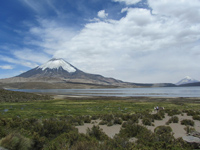
Andes MountainsThe Andes make up the world’s longest continental mountain range. The range stretches 4,300 miles in length, 430 miles in width, with an average height of about 13,000 feet. The Andes extend through Venezuela, Colombia, Ecuador, Peru, Bolivia, Chile, and Argentina. The mountains are separated into three divisions based on their climate: the Tropical Andes, the Dry Andes, and the Wet Andes. The Andes are part of the American Cordillera, a chain of mountain ranges that make an almost continuous line of mountains that form the western “backbone” of North, Central, South America and Antarctica. |
| Back to Map | |
 |
Strait of MagellanThe Strait of Magellan is a water passage through the Tierra del Fuego region of Chile and Argentina that leads from the Atlantic to Pacific Ocean. Before the construction of the Panama Canal, the Strait of Magellan was the only way ships could navigate between the two oceans. On November 1, 1520, Ferdinand Magellan and his expedition successfully navigated through the treacherous, stormy, and windy strait. Upon his exit from the strait, Magellan is said to have named the ocean he saw "Mar Pacifico," or, the Pacific Ocean, because it seemed so calm compared to the Straits. At first , the strait was called the Strait of All Saints, but it was eventually renamed to honor Magellan, who was killed the following year in Asia. |
| Back to Map | |
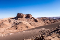 |
Atacama DesertThe Atacama Desert is the driest place on Earth. It is the only desert to receive less rain, snow, sleet, or hail than the polar deserts. The topography of the desert includes salt lakes, sand, stones, and felsic lava and molten rock flowing towards the Andes area. The cold Humboldt ocean current, a cold north-flowing stream of water on South America’s west coast, causes a temperature inversion that accounts for the desert’s extremely dry conditions. The driest part of the desert is located between the Andes and Chilean Coast mountain regions, where moisture is unable to permeate the height of the mountains. |
| Back to Map | |
\ |
|
| La Paz | |
| Population: | 18,050,000 |
| Area: | 291,930 sq. miles |
| Capital City: | Santiago |
| Largest City: | Santiago |
| Currency: | Chilean Peso |
| Official Language: | Spanish |
| GDP (Gross Domestic Product) | $506 Billion |
|
|
 |
|
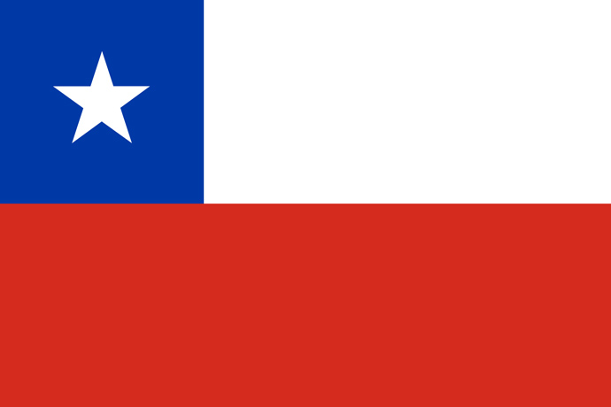
| The Chilean flag is composed of three main colors: red, white, and blue. The blue represents the sky and the Pacific Ocean, the white represents the snow-covered Andes Mountains, and the red represents the blood that was shed in order for the country to gain its independence. The star located in the top left is thought to reference Chile’s independence or serve as a symbol of honor and progress. | |