Click on the map below to learn more
 |
IqaluitIqaluit is the capital and largest (and only) city of Nunavut. It has a population of 7,740, and was made capital of the territory when it broke away from the Northwest Territories. Although it is located south of the Arctic Circle, it has a polar climate and is freezing cold for much of the year. The summers in Iqaluit are so short, and the soil so frozen, that only small trees can survive such as the Arctic willow. The highest temperature ever recorded in the city is only 80 degrees Fahrenheit (in 2008). Iqaluit was an important fishing grounds for the native Inuit people. The name "Iqaluit" means "place of many fish." Prior to being called Iqaluit, the city was known as Frobisher Bay.
|
| Back to Map | |
 |
Baffin IslandBaffin Island is the largest island in Canada and the fifth largest island in the world. Covering an area of 195,000 square miles, it is significantly larger than the state of California. The island was named after English explorer William Baffin, although it is believed that Viking explorers such as Erik the Red and Leif Erikson were familiar with it. About 13,000 people live on Baffin Island, which is filled with icefields, rugged mountains, and tundra. Polar bears, Arctic foxes, lemmings, and snowy owls are commonly found throughout Baffin Island. Narwhals, beluga whales, and walrus are found along its coasts. Baffin Island experiences long, freezing cold winters, and very short, foggy summers. Heavy snow can occur any time of the year, including in the middle of summer! |
| Back to Map | |
 |
AlertLocated more than 500 miles north of the Arctic Circle, Alert is the northernmost permanently inhabited place in the world. Alert has a population of 62, but it fluctuates depending on the various operations occurring. There are no permanent residents but there are always temporary residents. Alert is the home of a Canadian military intelligence station as well as an environmental monitoring station and a weather station. Alert even has a small airport operated by the Canadian military. It takes its name from a ship called the HMS Alert - a Canadian naval vessel that wintered in the region in 1875 and 1876. |
| Back to Map | |
 |
Quasuittuq National ParkQuasuittuq National Park is a remote park in northern Nunavut. Its name means "place where the sun does not rise" in Inuit. The park is typical of lands in the high Arctic Archipelago with severe, cold winters and short, cool summers. The park is home to typical Arctic wildlife such as Arctic foxes, polar bears, caribou, wolves, and muskoxen. Narwhal, walrus, seals, and beluga whales are common in surrounding water. From November through January, the park is in perpetual darkness. |
| Back to Map | |
 |
Auyuittuq National ParkAuyuittuq National Park is located on the coast of Baffin Island. Its name means "the land that never melts" in Inuit. The park is filled with Arctic landforms such as fjords, glaciers, icefields, and rugged mountains. Because of the harsh climate, few plants can grow at Auyuittuq, which in turn, limits wildlife to typical Arctic species such as polar bears, Arctic foxes, wolves, Arctic hares, snowy owls, ptarmigan, gyrfalcons, and others. Beluga whales, narwhals, seals, and walruses are marine mammals that can be found in the park. |
| Back to Map | |
 |
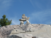
Barbeau PeakRising to 8,583 feet, Barbeau Peak is the highest peak in Nunavut, and the highest peak in the Canadian Arctic. The mountain was named after Dr. Marius Barbeau, a Canadian anthropologist who studied the Inuit culture.
|
| Back to Map | |
 |
|
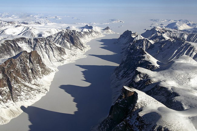
| An ice-covered fjord on Baffin Island | |
| Population: | 39,170 |
| Area: | 787,155 sq. miles |
| Capital City: | Iqaluit |
| Largest City: | Iqaluit |
| Currency: | Canadian Dollar |
| Official Language: | English, French, Inuktitut |
| GDP (Gross Domestic Product) | $2 Billion |
|
|
 |
|
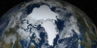
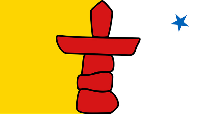
| The Nunavut flag is dominated by a red inuksuk. An inuksuk is a stone monument made by Inuit people as landmarks when traveling through the barren and snowy tundra. It is red to represent Canada. The blue star in the upper right of the flag represents Niqirtsuituq (the North Star) and the leadership provided by the Inuit elders. The colors yellow and blue represent the riches of the land, sea, and sky. | |