Click on the map below to learn more
 |
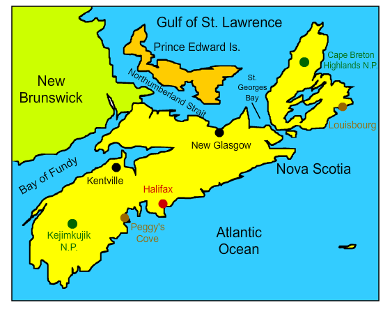
HalifaxWith a population of about 403,000, Halifax is the capital of Nova Scotia and the largest city in Canada’s Maritime provinces. It is a major port and center of government, tourism, health care, and education. Halifax has played an important role at the intersections of British, French, Native, and American histories. Its very establishment resulted in bloodshed and warfare. For many years, the British had tried to gain control of the region from the native peoples and French Acadian settlers. The establishment of Halifax as a major English settlement in 1749 resulted in the bloody six-year war known as Father Le Loutre’s War between the British Mi'kmaq people and Acadian settlers. The British victory in the war resulted in the expulsion of most of the Acadian peoples from the region and was a precursor to the French and Indian War. Following British control of the area, Halifax became a major British military base in the French and Indian War and the Revolutionary War.
|
|
| Back to Map | ||
 |
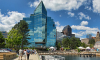
KentvilleLocated on the Cornwallis River, Kentville was first settled by the Acadians - who built dikes to keep the powerful tides of the Bay of Fundy from destroying their crops in the early 1700s. In 1755, the Acadians were expelled from Nova Scotia by the British and the area, then known as Horton's Corner, was quickly settled by New England planters. In the early 1800's, the town was nicknamed "Devil's half-acre" because it attracted a rowdy clientèle of drinkers and horse racers. The advent of the railroads in the 1860s gave rise to Kentville's thriving apple industry, which became its major product. Today, apples remain an important part of Kentville's economy. Since 1933, the city has hosted a popular Apple Blossom Festival in May. It also hosts an annual "Pumpkin People Contest" where people make life-sized figures with pumpkin heads and parts. |
|
| Back to Map | ||
 |
New GlasgowNew Glasgow, named after Glasgow, Scotland, was founded in 1809. After large coal deposits were found in the region, New Glasgow developed into a thriving mining and port community. By 1840, New Glasgow became a center of shipbuilding. Today, New Glasgow's economy is driven by health care, a Michelin tire factory, a pulp mill, and the headquarters for a national grocery chain. In recent years, the city has fallen on hard times as many former employers have left the area or reduced their presences. Its population has dropped by over 20 percent since 1980. |
|
| Back to Map | ||
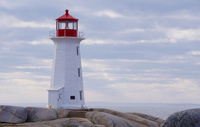 |
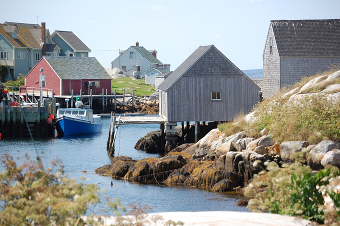
Peggy's CovePeggy's Cove is a small fishing village located in St. Margaret's Bay in Nova Scotia. Its history dates back to six German families who settled the land in 1811. The families fished, farmed, and raised cattle. The population slowly grew and a schoolhouse, church, general store, and lobster cannery were built, along with wooded houses along the inlets and massive ocean boulders. Although the villagers of Peggy's Cove still subsist on fishing, tourism now drives its economy. The village now hosts an annual fine arts festival and is famous for its homemade ice cream and gingerbread. One of the its tourist attractions is Peggy's Point Lighthouse, Canada's most iconic lighthouse. Dating back to 1915, it claims to be one of the world's most photographed lighthouses. |
|
| Back to Map | ||
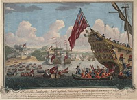 |
LouisbourgThe Battle of Louisbourg, in present day Nova Scotia, was one of the most important British victories in the French and Indian War. It marked a change of strategy in how the British fought the war. After several setbacks in the Ohio River Valley, British Prime Minister William Pitt decided that the best strategy for winning the war would be to attack New France in Canada. In 1758, Parliament planned an attack on the Fortress of Louisbourg, which stood in the way of a large-scale British attack on the rest of Quebec using the St. Lawrence River. On May 29, 1758, nearly 14,000 men on 150 transport ships and 40 war ships anchored in Gabarus Bay, just three miles from Louisbourg. They were under the command of Jeffrey Amherst. The French defense consisted of about 7,000 soldiers manning the cove and in war ships on the harbor.The British siege lasted over a month and a half. For several weeks, they made hardly any progress in taking the fortress. Eventually, however, their soldiers managed to secure the shore, and the constant pounding from British cannons and guns penetrated the walls of the great fortress, setting large sections of it ablaze. One-by-one, the French warships in the harbor were also destroyed. Finally, on July 26, 1758, French forces surrendered the fortress, which was promptly destroyed by the British. The British now had control of the vital St. Lawrence River. |
|
| Back to Map | ||
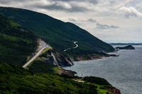 |
Cape Breton Highlands National ParkCape Breton Highlands National Park was the first national park established in Atlantic Canada. The park features mountains, steep cliffs, deep river canyons, valleys, waterfalls, and rocky coastlines. Cabot Trail, a scenic highway on Nova's Scotia's coastal mountains, passes through a portion of the park. Some consider Cabot Trail the most scenic drive in all of North America.
|
|
| Back to Map | ||
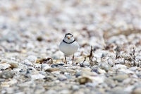 |
Kejimkujic National ParkKejimkujic National Park is the only Canadian park that is both a national park and national historic site. The dark sky preserve is well-known for its pristine lakes, sandy beaches, dunes, and beautiful acadian forests. The dunes are home to numerous shorebirds including the rare piping plover. At night, visitors can see the dazzling night sky, undisturbed by artificial lights. The park also features petroglyphs carved into stone left behind by the native Mi’kmaq people hundreds or even thousands of years ago. |
|
| Back to Map | ||
 |
||
| Peggy's Cove | ||
| Population: | 966,800 | |
| Area: | 21,300 sq. miles | |
| Capital City: | Halifax | |
| Largest City: | Halifax | |
| Currency: | Canadian Dollar | |
| Official Language: | English | |
| GDP (Gross Domestic Product) | $42.175 Billion | |
|
||
 |
||
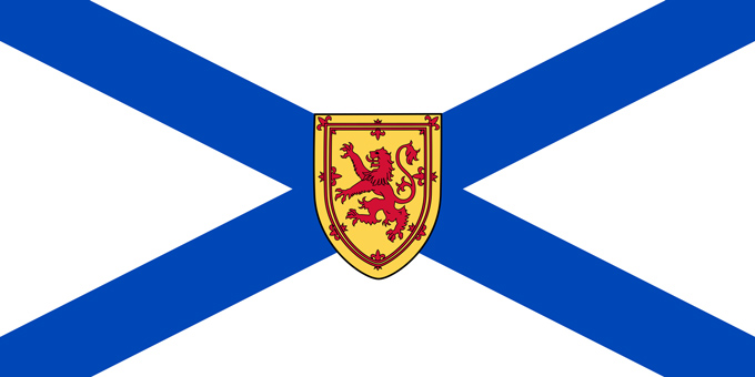
| Despite its 155-year existence, the current flag was only named Nova Scotia's official flag in 2013. The flag features a blue saltire on a white field and is the opposite of the Scotland flag which has a white saltire against a blue field. The shield with the lion in the middle is the Nova Scotia coat of arms. The width of the Nova Scotia Flag is set to be exactly twice its height. | ||