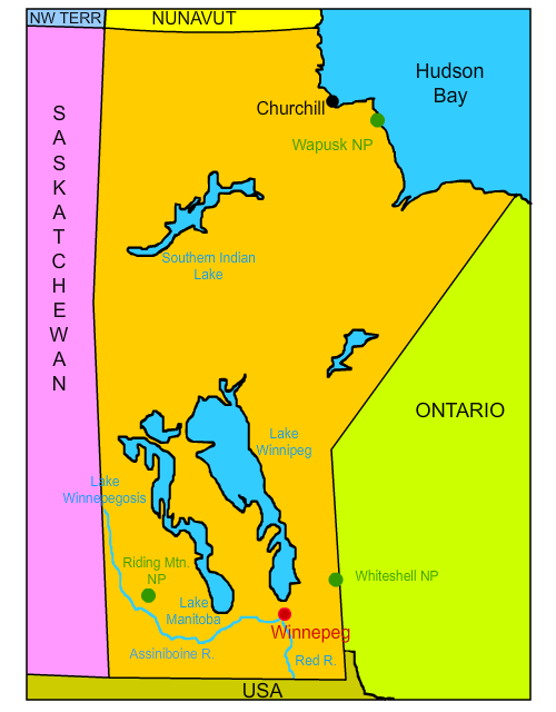
Click on the map below to learn more
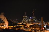 |
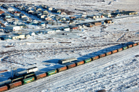
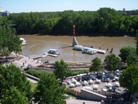
WinnipegLocated on the confluence of the Assiniboine and Red Rivers, Winnipeg is the capital and largest city of Manitoba. About 800,000 people live in or around Winnipeg, which is about 100 miles from the United States border. The city was named after nearby Lake Winnipeg. In native Cree language, "Winnipeg" means muddy waters. Winnipeg is famous for its bitterly cold winters. The average low temperature in January is -6 degrees Fahrenheit. Sometimes referred to as "gateway to the west," Winnipeg is a major transportation and railway center. It is home to the Winnipeg Jets of the National Hockey League (NHL) and hosts several important Canadian festivals such as Festival du Voyageur, a 10-day winter festival that celebrates Winnipeg's history as a fur-trading center, and Folklorama, a festival that celebrates the diverse cultures of Winnipeg's people. It is supposedly the world's oldest and largest multicultural festival.
|
|
| Back to Map | ||
 |
ChurchillLocated on the western shores of Hudson Bay, Churchill is known as the "polar bear capital of the world," and has become a popular tourist attraction for those willing to travel to its remote location for a chance to see polar bears in the wild. Visitors to Churchill can board tundra-designed vehicles to safely view the bears as thousands migrate through the region searching for ringed seals. In the summer, thousands of beluga whales move into the relatively warm waters of the Churchill River. These whales are easily viewed by those on boat tours. The community of Churchill is very small and has a population of about 900 permanent residents who brave about seven months of freezing cold temperatures. In fact, the average HIGH temperature in January is -15 degrees Fahrenheit. Its location is so remote that there are no roads leading from it to other parts of Manitoba.
|
|
| Back to Map | ||
 |
Riding Mountain National ParkLocated in western Manitoba, Riding Mountain National Park is one of the most unique national parks in Canada. Within the park are three distinct ecosystems: prairie, boreal forest, and eastern deciduous forest. The park is located atop the Manitoba Escarpment. An escarpment is an eroded long slope or steep cliff that separates two level areas with different elevations. In 1931, British-born Archibald Belaney was hired as a caretaker in the park. He would eventually take on the native name "Grey Owl" and would become one of Canada's greatest conservationists - becoming an international voice for conservation and the negative impact of people on the natural world. Several books have been written and documentaries filmed regarding the controversial life and identity of Grey Owl. Although his contributions to the conservation efforts can never be questioned, his stories on how he became "Grey Owl" are thought to be mostly fabricated. |
|
| Back to Map | ||
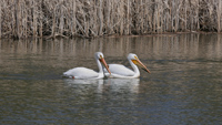 |
Lake WinnipegLake Winnipeg is a huge freshwater lake in central Manitoba. Covering an area of 9,465 square miles, it is the eleventh largest lake in the world and the third largest entirely within Canada - although its watershed is the largest of any lake in Canada. It is relatively shallow, with an average depth of about 39 feet. Most of the islands within the lake are undeveloped and provide critical nesting habitat for white pelicans, terns, gulls, and cormorants. The east side of the lake, which features pristine boreal forests and wild rivers, known as Pimachiowin Aki, recently became a UNSECO World Heritage Site. The area covers the ancestral lands of several native groups in Manitoba and Ontario. |
|
| Back to Map | ||
 |
Lake WinnipegosisLake Winnipegosis is Canada's eleventh largest lake and covers about 2,100 sq. miles in area. Its name means "little muddy waters" in native language. Like Lake Winnipeg and Lake Manitoba, Winnipegosis was formed from the remains of the prehistorical glacial Lake Agassiz - which covered a large portion of central North America during the last ice age some 13,000 years ago. Lake Agassiz was larger than all five of the Great Lakes, and Manitoba's three large lakes, combined. |
|
| Back to Map | ||
 |
Lake ManitobaLake Manitoba is Canada's 13th largest lake. The lake's name comes from a Cree or Ojibwa term translated to "straits of Manitou." Manitou was the "Great Spirit." Early French explorers called the lake "Lac de Prairies," which means Lake of the Prairies. Lake Manitoba might be best known however, as the home of Manipogo. According to legend, Manipogo is a large lake monster, measuring up to 50 feet long. It is said to be similar to the Loch Ness Monster. The legend has grown so popular, that Manitoba named a provincial park on the west side of the lake Manipogo Provincial Park. |
|
| Back to Map | ||
 |
Assiniboine RiverNamed for the Assiniboine First Nation, the Assiniboine River flows for about 660 miles through the prairies of southern Manitoba and Saskatchewan. The river was an important center for both French and British fur traders in the early and mid-1700s. The Assiniboine flows into the Red River at Winnipeg. The confluence of the two major rivers is known as "the forks." |
|
| Back to Map | ||
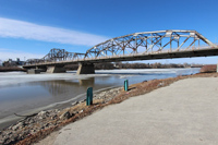 |
Red RiverSometimes called the Red River of the North to distinguish it from other Red Rivers in the United States, the Red River joins the Assiniboine River to form "the forks" at Winnipeg, Manitoba. It is unusual among rivers in that it flows north. |
|
| Back to Map | ||
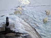 |
Wapusk National ParkLocated about 30 miles south of Churchill on the shores of the Hudson Bay, Wapusk is one of Canada's newest national parks. The name "wapusk" means polar bear in Cree language. The park contains Cape Churchill - a narrow strip of land that extends far out into the bay. Many believe Cape Churchill is the best place on Earth to observe and photograph polar bears. In 2010, it was revealed that grizzly bears had been spotted at Wapusk National Park for the first time, likely because of climate change. The presence of grizzly bears in Wapusk is alarming because they are known to dominate, displace, and even kill polar bears. |
|
| Back to Map | ||
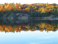 |
Whiteshell Provincial ParkWhiteshell Provincial Park is located in eastern Manitoba, near the border of Ontario. The park preserves a portion of the vast Canadian Shield wilderness and features boreal forests, lakes, and granite cliffs. West Hawk Lake, located within the park, is the deepest lake in Manitoba and was likely formed by a meteor strike about 350 million years ago. Whiteshell also features several museums dedicated to Manitoba's history including the Whiteshell Trappers Museum, the Whiteshell Natural History Museum and the West Hawk Museum, which features exhibits that honor the region's geological history. |
|
| Back to Map | ||
 |
||
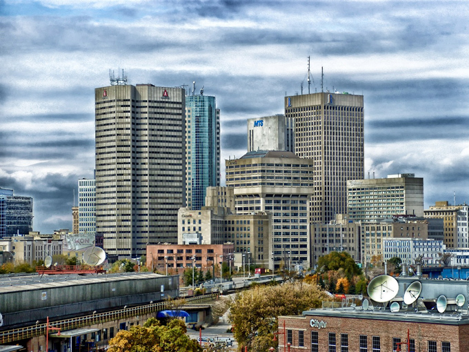
| Winnipeg Skyline | ||
| Population: | 1,363,000 | |
| Area: | 250,950 sq. miles | |
| Capital City: | Winnipeg | |
| Largest City: | Winnipeg | |
| Currency: | Canadian Dollar | |
| Official Language: | English | |
| GDP (Gross Domestic Product) | $66 Billion | |
|
||
 |
||
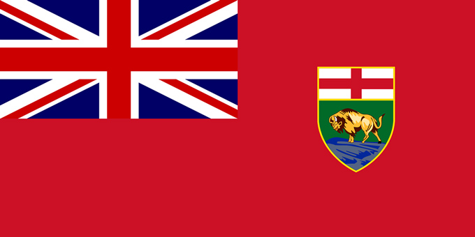
| Manitoba's flag features a red ensign and a Union Jack in the canton (upper left portion of a flag). The Manitoba coat-of-arms is on the right side of the flag. The coat of arms features St. George's Cross above a bison. The bison symbolizes the great herds that once fed and clothed Manitoba's first nations and eaarly settlers. | ||