Click on the map below to learn more
 |
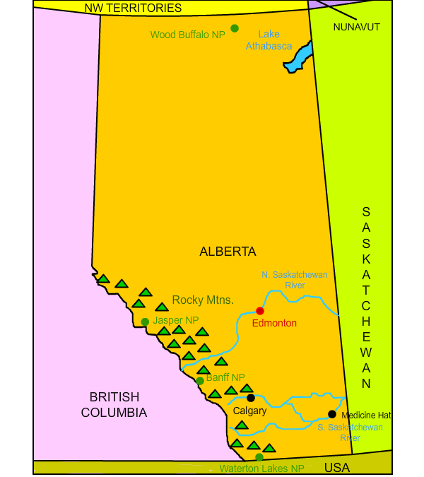
CalgaryLocated at the junction of the foothills of the Rocky Mountains and the Great Plains in southern Alberta, Calgary is the largest city in Alberta and the fourth largest city in Canada. It is a major center of oil, gas, and energy production, finance, transportation, technology, and manufacturing. Originally named Fort Brisebois, it was re-named Fort Calgary in 1876 and was a North-West Mounted Police (now Royal Canadian Mounted Police) post established to protect the region's fur trade and to discourage American whiskey traders from dealing in the area. Over 1.3 million people live in and around Calgary. It is sometimes called "Cowtown" or "Stampede City." Today, Calgary is often named one of Canada's most livable cities. Calgary is home to the Flames, one of two NHL (National Hockey League) teams that play in Alberta. In 1988, Calgary became the first Canadian city to host the Winter Olympics. Calgary may be best known for the Calgary Stampede, an annual rodeo festival since 1912 that now attracts over one million people each July. Its organizers call it the "Greatest Outdoor Show on Earth." In addition, Calgary is often the first destination for people around the world visiting Banff and Jasper National Parks.
|
|
| Back to Map | ||
 |
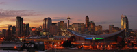
EdmontonEdmonton is the capital and second largest city of Alberta. Over 1.3 million people live in and around the city, making it slightly smaller than Calgary. It is the northernmost major city in North America. It is the fifth largest city in Canada. Fort Edmonton was founded in 1795 as a trading post of England's Hudson Bay Company. It was named after the hometown of the fort's founder. The city began to grow in the late 1800s with the advent of several railway lines. Its rich soil attracted immigrants from around the world, making the city a major center of agriculture. On July 31, 1987, the city was struck by a devastating tornado that killed 27 people. The day became known as "Black Friday." Today, Edmonton is sometimes known as "The Gateway to the North." It is home to the West Edmonton Mall, one of North America's largest shopping malls. 32 million people visit the mall every year. It is also home to Fort Edmonton Park, Canada's largest living history museum. Edmonton is also home to the NHL's (National Hockey League) Edmonton Oilers. The Oilers won four Stanley Cups in the 1980s. During this time the Oilers' Wayne Gretzky became widely acknowledged as one of the greatest hockey played to have ever lived. |
|
| Back to Map | ||
 |
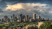
Medicine HatMedicine Hat is an industrial city in the vast plains of eastern Alberta. It is located in the heart of the region known as Palliser's Triangle, a semi-arid steppe region perfect for agriculture but also prone to drought and dust storms. It was once called the "Pittsburgh of the West" and "Gas City" because of the coal and natural gas operations in the region. Medicine Hat was largely established as a transportation point by the Canadian Pacific Railway in 1883. The name "Medicine Hat" most likely comes from a Blackfoot word for an eagle tail feather headdress worn by medicine men. Today, the city is home to about 63,000 people who enjoy its sunny weather. Medicine Hat is one of Canada's sunniest cities.
|
|
| Back to Map | ||
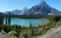 |
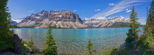
Banff National ParkBanff National Park is one of the world's most famous national parks and the oldest national park in Canada. Located in the Canadian Rockies, the park is famous for its incredible vistas, glaciers, alpine ecosystems, boreal forests, and of course, the crystal-blue Lake Louise. Visitors can view over 100 glaciers on the Icefields Parkway, which connects Banff to Jasper National Park to the north. Grizzly bears, black bears, moose, bighorn sheep and mountain lions, are among the species that can be observed in the park. Established in 1885, the Canadian Pacific Railway built two hotels: The Banff Springs Hotel and the Chateau Lake Louise, which attracted visitors from around the world. Today, over three million people visit the park each year. |
|
| Back to Map | ||
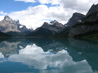 |
Jasper National ParkJasper National Park is the largest national park in the Canadian Rockies. It features glaciers, icefields, hot springs, lakes, waterfalls, caves, canyons, and high mountains. It is connected to Banff National Park to the south via the Icefields parkway. It was established in 1907 and named after Jasper Hawes, who operated a trading post in the region. Well over two million people visit every year. |
|
| Back to Map | ||
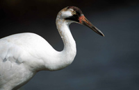 |
Wood Buffalo National ParkWood Buffalo National Park is the largest national park in Canada, the second largest in the world, and one of the most important on Earth. It was established in 1922 to protect the world's last remaining herd of wood buffalo, that numbered about 500 at the time. It is also one of only two known breeding sites of the highly endangered whooping crane. The park features one of the world's largest freshwater deltas at the confluence of the Peace, Athabasca, and Birch Rivers. The park was made a UNESCO World Heritage Site in 1983 and recently became the world's largest dark sky preserve. In 2007, the world's largest beaver dam was discovered at Wood Buffalo National Park. It was more than half a mile long!
|
|
| Back to Map | ||
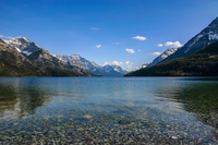 |
Waterton Lakes National ParkEstablished in 1895, Waterton Lakes is one of Canada's oldest national parks. It borders Montana's Glacier National Park and is located on the border of the Rocky Mountains and Great Plains. Together, the two parks form the Waterton-Glacier International Peace Park, devoted to world peace. Much like Glacier National Park, Waterton Lakes is known for its crystal-clear lakes, streams, waterfalls, and towering mountains. The park is home to grizzly bears, black bears, mountain lions, beavers, moose, and many other species, including over 250 species of birds. |
|
| Back to Map | ||
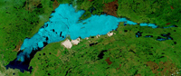 |
Lake AthabascaLake Athabasca is a large lake in northwestern Saskatchewan and northeastern Alberta, although 74 percent of the lake is in Saskatchewan. The name Athabasca is a Cree word meaning "there are plants one after another." Covering an area of about 3,000 square miles, it is the eighth largest lake in Canada. It is about 176 miles long and at its widest is 31 miles. Its maximum depth is 407 feet. Lake Athabasca was heavily contaminated in the 1980s by gold and uranium mining operations that were staged along its shores. In 2013, the lake was further contaminated by over 250 million gallons of wastewater from a coal mining operation. |
|
| Back to Map | ||
 |
South Saskatchewan RiverThe South Saskatchewan River rises at the confluence of the Bow and Oldman Rivers and flows 865 miles to its mouth in the Saskatchewan River. Both the North and South Saskatchewan Rivers are tributaries of the much smaller Saskatchewan River. For much of its history, the South Saskatchewan River would completely freeze in the winter, creating dangerous conditions in its port cities of Saskatoon and Medicine Hat, Alberta. In the 1960s, the construction of the Gardiner Dam diverted much of the water to the Qu' Appelle River, mitigating the danger. |
|
| Back to Map | ||
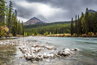 |
North Saskatchewan RiverThe North Saskatchewan River is a glacier-fed river that rises in Alberta's Rocky Mountains and flows about 800 miles to the Saskatchewan River. It passes through Banff National Park and flows alongside the famous Icefields Parkway. |
|
| Back to Map | ||
 |
||
| Banff National Park | ||
| Population: | 4,362,000 | |
| Area: | 255,541 sq. miles | |
| Capital City: | Edmonton | |
| Largest City: | Calgary | |
| Currency: | Canadian Dollar | |
| Official Language: | English | |
| GDP (Gross Domestic Product) | $326.4 Billion | |
|
||
 |
||
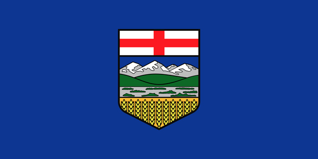
| The blue background of the flag represents Alberta's blue sky. Its coat of arms dominates the middle of the flag. St. George's Cross at the top of the coat of arms represents its ties to Great Britain, the mountains represent its Rocky Mountains, and the wheat represents the Great Plains. | ||