| |
Arizona |
| Click the points of the map below to learn more
|
| |
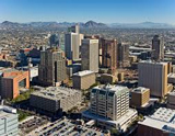 |
Phoenix, Arizona is the largest capital city in the United States. The city was founded in 1868 by a Confederate soldier from Wickenburg, Arizona named Jack Swilling. He envisioned the area as a great place to farm. In 1881, Phoenix was incorporated as a city. The city's population swelled after the railroads came to town, and after the construction of the Theodore Roosevelt Dam over the Salt River. The dam expanded irrigation of land in the valley for farming, and increased the water supply for the growing population.
Phoenix is located in the Sonoran Desert. It receives 300
days of sunshine per year.
Back to Map
|
| |
|
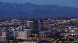 |
Tucson
Located in the heart of the Sonoran Desert, Tucson is the second largest city in Arizona. It was the capital of the Arizona Territory from 1867-1889. In 1885, the University of Arizona was chartered in Tucson. It was Arizona's first university and now has more than 37,000 students.
Today, Tucson is a rapidly growing city. 35 percent of the population is of Hispanic or Latino origin. The city is home to numerous resorts and retirement communities. It is also home to the Tucson Mineral and Gem Show, one of the largest such conventions in the world. 50,000 visitors come for the show every year.
Back to Map |
| |
|
 |
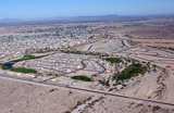
Mesa
Mesa is one of the fastest growing cities in the United States. It is the largest suburban city in America, and second largest in North America. In addition, Mesa has become the third largest city in Arizona, and currently has one of the highest Mormon populations in America.
In 2005, the Mesa Arts Center was completed, a $94 million dollar complex dedicated to the performing and contemporary arts, that features four theaters and numerous art exhibits.
Back to Map |
| |
|
 |
Colorado Plateau
The Colorado Plateau is a large 130,000 square mile plateau centered on the Four Corners region of the American southwest. A plateau is a relatively flat area of high land. The semi-arid region features remarkable rock formations such as cliffs, arches, canyons, natural bridges and monoliths. Precipitation that falls in the area is drained to the sea by the Colorado River.
The region is home to nine National Parks including Grand Canyon, Arches, and Zion.
Back to Map |
| |
|
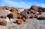 |
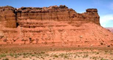
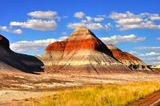
Petrified Forest National Park
Petrified Forest National Park contains one of the world's largest and most colorful concentrations of petrified wood in the world.
Petrified wood is fossilized wood that has turned into minerals such as chromium, manganese, silica, copper, cobalt, and iron.
Back to Map |
| |
|
 |
Yuma
Yuma, located on the borders of Arizona, Mexico, and California, is America's hottest city. Summertime high temperatures average 107 degrees Fahrenheit
Back to Map |
| |
|
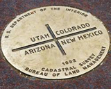 |
Four Corners
Four Corners is an area of the American southwest, in which the states of Utah, Colorado, Arizona, and New Mexico all meet. Visitors can position themselves to be in all four states at one time. It is the only place in America
where four states meet.
Back to Map |
| |
|
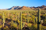 |
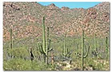
Saguaro National Park
Saguaro National Park, located in southeastern Arizona, was established as a refuge for the world's largest cactus - the Saguaro. The Saguaro Cactus is a unique plant, found only in the Sonoran Desert. It may grow to fifty feet in height, and live to over 150 years of age! It provides homes and nourish-ment for countless desert species, and is sometimes referred to as the "desert hotel".
Back to Map |
| |
|
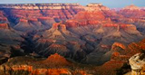 |
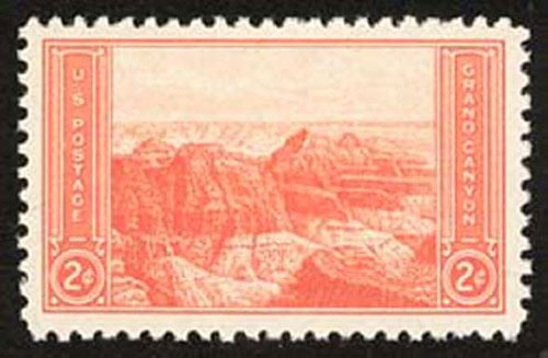
Grand Canyon National Park
Grand Canyon National Park, located in Northwestern Arizona, is one of the world's most dazzling sites. Carved over millions of years by the Colorado River, the Grand Canyon is 277 miles long, and between 4 and 18 miles wide.
In some places, the canyon is more than one mile deep. The Grand Canyon was first discovered by explorers searching for the fabled Seven Cities of Cibola in an expedition led by Spanish explorer Francisco Vasquez de Coronado in 1540.
Back to Map |
| |
|
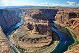 |
Colorado River
| Length: |
1,450 miles |
| Source: |
Rocky Mountain National Park |
| Outflow: |
Gulf of California |
| |
|
| The mighty Colorado River, which eventually flows through several national parks before carving the Grand Canyon, starts as a narrow stream near Lake Granby in Colorado's Rocky Mountain National Park. |
Back to Map |
| |
|
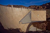 |
Hoover Dam
The Hoover Dam can store 9.2 trillion gallons of water in its reservoir, Lake Mead. It was named after president Herbert Hoover. The Hoover Dam was built for three reasons:
| 1.) To stop flooding caused by melting snow. |
| 2.) To enable irrigated farming in the desert region. |
| 3.) To provide water for southern California. |
Back to Map |
| |
|
 |
Painted Desert
The Painted Desert, located in northern Arizona, is an area of badlands with colorful buttes, flattop mesas, and hardened sand dunes, many of which seem to be "painted" with red and gray stripes from years of wind erosion. Many
towns within the Pained Desert are often covered in red dust blown in from the surrounding desert. Most of the desert's 95,000 square miles are located in the Navajo Indian Reservation. The Navajo use the abundant red clay in the area to make pottery, which is sold in nearby souvenir shops and roadside stands.
Back to Map |
| |
|
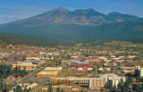 |
Flagstaff
Flagstaff was founded in 1876 by Massachusetts settler Thomas McMillan. The town was named after a tall Ponderosa pine tree that was made into a flagpole in commemoration of America's 100th birthday. In 1894, Flagstaff was made the site of the Lowell Obervatory, one of the oldest observatories in the nation. The dwarf planet Pluto was discovered there in 1930.
Today, Flagstaff is very popular toruist attraction for its excellent skiing and outdoor opportunities. The city is located next the world's largest Ponderosa Pine forest.
Back to Map |
| |
|
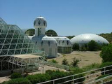 |
Biosphere 2
Biosphere 2 was a scientific experiment testing whether people could live and work in an airtight biosphere. The 200 million dollar project also explored the use of closed biospheres in space colon-ization. In the early stages of the
experiment, people were sealed inside! Biosphere 2 had special sections that featured different ecosystems such as rainforest, jungle, and desert. The project allowed re-searchers to study the results of environmental manipulation within the sections without actually harming the Earth's real ecosystems.
Back to Map |
| |
|
 |
Gila River
The Gila River begins in the moun-tains of southwestern New Mexico and flows through Arizona to the Colorado River. It is 644 miles long. The Gila River served as the border between the United States and Mexico from 1848 to 1853.
Back to Map |
| |
|
 |
Rocky Mountains
The legendary Rocky Mountains extend through much of western North America from Canada to New Mexico. The "Rockies," as they are often called, stretch over
2,000 miles.
Highest Point:
|
Mt. Elbert (CO) 14,433 ft |
| Highest Point in Arizona: |
Humphrey's Peak (12,633 ft.) |
Back to Map
|
| |
|
 |
Sonoran Desert
The Sonoran Desert covers 3,035,122 Acres in Arizona and Mexico. It is the world's most biologically diverse desert and contains the entire world's population of Saguaro Cacti, large cacti that provide homes to Sonoran animals. Such cacti live over 150 years.
The Sonoran Desert is also home to the Harris Hawk, a species of hawk that hunts in groups (kind of like a pack of winged wolves), and the Elf Owl, the world's smallest owl.
Back to Map |
| |
|
|
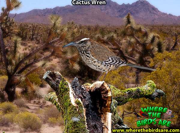
| Arizona State Bird |
| |
|
| |
| Top Five Facts |
| |
1. ) Arizona was the last of the contiguous 48 states to join the Union, which it did on February 14, 1912. |
2. ) Arizona's Sonoran Desert is the world's most biologically diverse desert. |
3. ) Arizona is one of two states that does not observe daylight savings time. |
4. ) The former planet Pluto was discovered at the Lowell Observatory in Flagstaff, Arizona. |
5. ) Arizona is home to the nation's largest Native American reservation (Navajo Nation - which covers an area larger than the state of West Virginia. It spills out into Utah and New Mexico as well.) |
| |
| Arizona in History |
| |
1540-1542: Francisco Vazquez de Coronado explores Arizona searching for the Fabled Seven Cities of Cibola.
1600's-1700's: Spanish miners descend upon the region searching for silver.
1848: As a result of the Mexican War, Mexico cedes much of Arizona to the United States.
1849: Thousands of prospectors travel through Arizona on their way to the California Gold Rush.
1850: Most of Arizona is organized into the New Mexico Territory.
1853: Authorized by President Franklin Pierce, the remainder of Arizona is purchased in the Gadsden Purchase.
1862: Union military forces score a minor victory at the Battle of Pacacho Pass. This battle marked the only battle fought in Arizona during the war.
1862: Apaches attack U.S. soldiers - which begins a ten year war with the settlers.
1863: The Territory of Arizona is created from the New Mexico Territory.
1864: Kit Carson captures 7,000 Navajos and makes them leave Arizona in what came to be known as "The Long Walk."
1869: John Wesley Powell explores the Grand Canyon in a boat
1877: The Desert Land Act of 1877, giving settlers 640 acres in the region, attracts thousands of settlers.
1878: The boomtown of Tombstone is founded. The town came to epitomize the "Wild West" and was the scene of the famous Gunfight at the O.K. Corral, which lead to a prolonged political feud in the region.
1919: Grand Canyon National Park is founded.
1936: The Hoover Dam is finished
1948: Native Americans gain the right to vote
1975: Raul H. Castro becomes the first Mexican- American Governor or Arizona
1981: First woman on the U.S. Supreme court, Sandra Day O' Connor is elected.
|
|
|