Click on the map below to learn more
 |
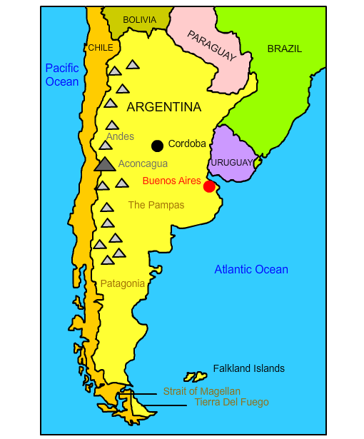
CórdobaLocated about 430 miles northwest of Buenos Aires, Córdoba is the second largest city in Argentina. It has a population of over 1,300,000 people. It was founded in 1573 and named after Córdoba, Spain. In 1613, the National University of Córdoba was founded, making it the oldest institute of higher education in Argentina. Today, Córdoba is a diverse city with a healthy economy. It is considered the technological hub of Argentina. Intel and Motorola are among the technology companies that maintain a presence in the city. In addition, Córdoba is one of South America's centers for automobile and automobile parts production. Córdoba's La Mundial claims to be the world's most narrow building. |
| Back to Map | |
 |
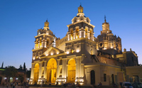
Buenos AiresBuenos Aires is the largest city and capital of Argentina . Located on the banks of the Rio de la Plata, it remains a major South American port, despite the fact it lies 150 miles west of the Atlantic Ocean. The area was first colonized by the Spanish in 1536, and settled around 1580. In 1853, Buenos Aires seceded from Argentina because of a dispute over the nation’s constitution and national political control. Buenos Aires reunited with Argentina in 1862, after it was declared the Argentine capital. Today, it is a diverse city with large populations of Spanish, French, Italian, Eastern European peoples. It is the commercial, financial and cultural center of Argentina. It is also a major food-processing center, with huge meatpacking and refrigeration plants and flour mills. Buenos Aires is a major cultural center, home to many landmarks and attractions including the National Library; the Teatro Colon, one of the world’s most famous opera houses; and the Museum of Latin American Art (Malba). |
| Back to Map | |
 |
AndesThe Andes make up the world’s longest continental mountain range. The range stretches 4,300 miles in length, 430 miles in width, with an average height of about 13,000 feet. The Andes extend through Venezuela, Colombia, Ecuador, Peru, Bolivia, Chile, and Argentina. The mountains are separated into three divisions based on their climate: the Tropical Andes, the Dry Andes, and the Wet Andes. The Andes are part of the American Cordillera, a chain of mountain ranges that make an almost continuous line of mountains that form the western “backbone” of North, Central, South America and Antarctica. |
| Back to Map | |
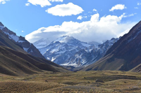 |
AconcaguaAconcagua, located in the southern Andes, rises to a height of 22,837 feet. It is both the tallest peak in South America and in the entire Western Hemisphere. Despite its imposing height, Aconcagua is considered an easy climb (for experienced mountain climbers). In 1897, British mountain climber Edward FitzGerald accomplished the first documented ascent of Aconcagua. Today, Aconcagua suffers from human waste pollution. While there are bathroom facilities on parts of the mountain, climbers must pay to use them and they are said to be only available for organized expeditions. |
| Back to Map | |
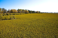 |
The PampasThe Pampas is a massive area of plains and lowlands in Argentina between the Atlantic Ocean and Andes Mountains. At over 289,000 square miles, the Pampas covers an area larger than the state of Texas. The Pampas is characterized by short grasses and very few trees due to frequent wildfires. The region's warm temperatures and high humidity sometimes give rise to intense thunderstorms that develop in the spring and summer. The Pampas is the only region in the world, other than the central United States and Canada, that commonly has tornadoes. |
| Back to Map | |
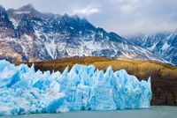 |
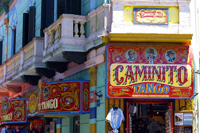
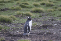
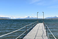
PatagoniaShared by both Chile and Argentina, Patagonia is a scenic region that is bordered by the Atlantic, Pacific, and Southern Oceans. It extends through much of southern Argentina. The area was named by Portuguese explorer Ferdinand Magellan, who used the word patagón to describe its native people. These people were said to be much taller than typical Europeans, and Magellan and his crew believed them to be giants. The sparsely populated region is known for its spectacular landscapes and pristine ecosystems. It features vast plains, mountain vistas, petrified forests, lakes, volcanoes, and glaciers. |
| Back to Map | |
 |
Falkland IslandThe Falkland Island are located about 300 miles off the east coast of the Patagonia region of Argentina. These islands are actually part of the British Empire, although Argentina claims them as its own. Most of the 3,400 people who inhabit the islands are of British descent and speak English. In 1982, however, Argentina invaded the Falklands and two other islands and attempted to assert control over the region. In what came to be known as the Falklands War, over 900 military personnel and three Falkland Islanders were killed before Argentina surrendered. In all, the "war" lasted 74 days. |
| Back to Map | |
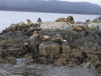 |
Tierra del FuegoTierra del Fuego describes the archipelago at the southern tip of South America. Its name means "land of fire" in Spanish. It was named by members of Ferdinand Magellan's expedition in 1520 for the many bonfires built by the native people of the region. The area is characterized by a subpolar climate and features jagged mountains and ancient glaciers. Only six species of trees grow in Patagonia, and many of those are twisted into interesting forms by the fierce winds. Despite its unforgiving climate, ecotourism is becoming increasingly popular in Patagonia. The region also serves as a staging ground for Antarctic voyages. Gas and oil extraction and sheep farming are also important. Interestingly, the North American beaver is considered an invasive species in Tierra del Fuego and has done significant damage to the region's fragile forests. |
| Back to Map | |
 |
Strait of MagellanThe Strait of Magellan is a water passage through the Tierra del Fuego region of Chile and Argentina that leads from the Atlantic to Pacific Ocean. Before the construction of the Panama Canal, the Strait of Magellan was the only way ships could navigate between the two oceans. On November 1, 1520, Ferdinand Magellan and his expedition successfully navigated through the treacherous, stormy, and windy strait. Upon his exit from the strait, Magellan is said to have named the ocean he saw "Mar Pacifico," or, the Pacific Ocean, because it seemed so calm compared to the Straits. At first , the strait was called the Strait of All Saints, but it was eventually renamed to honor Magellan, who was killed the following year in Asia. |
| Back to Map | |
| Population: | 43,487,000 (32) |
| Area: | 1,073,500 sq. miles (8) |
| Capital City: | Buenos Aires |
| Largest City: | Buenos Aires |
| Currency: | Argentine Peso |
| Official Language: | Spanish |
| GDP (Gross Domestic Product) | $921 Billion (25th) |
|
|
 |
|
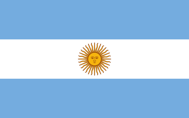
| The blue in Argentina's flag represents the sky, the white represents the clouds, and the symbol in the center of the flag represents the sun. Known as the "Sun of May," the symbol may pay homage to the Incan God of the Sun, Inti. The flag was designed by Manual Belgrano, leader of the Argentine Revolution against Spain. | |