Click on the map below to learn more
 |
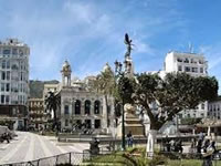
Algiers, AlgeriaAlgiers is the largest and most important city in Algeria.As of 2009, its population was about 3.6 million. Its history can be traced back to 944 AD, when it was founded by Bologhine ibn Ziri, founder of the Berber Zirid-Sanhaja Dynasty. Part of Algiers is said to be built upon the ruins of the ancient Roman city called Icosium. In the 1500's, Algiers was the headquarters of the notorious Barbary Pirates. who served as the naval branch of the Ottoman Empire. The Barbary Pirates would capture and enslave unlucky European sailors and would demands "tributes" or payments from nations in exchange for the free navigation of their trading vessels through the Mediterranean. One of the most famous sections of Algiers is called "the Casbah" (the Citadel) and is built upon a hill which gradually descends to the Mediterranean Sea. "The Casbah" is famous for its many 17th century mosques. |
| Back to Map | |
 |
Oran, AlgeriaOran is the second largest city in Algeria. It is a major port and commercial, industrial, and educational center of western Algeria. Its population is near 800,000 people. The city's history dates back to the early tenth century, when it was founded by Moorish traders. At various times in its history, Oran has been occupied by the Spanish, Turks, and French. |
| Back to Map | |
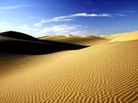 |
Sahara DesertCovering 3.6 million square miles, the Sahara Desert is the world's largest non-polar desert. It is also the world's hottest and sunniest desert. Covering most of north Africa, the Sahara Desert is roughly the size of the entire United States. Windswept sand dunes in the desert can reach heights of nearly 600 feet. Parts of the Sahara Desert can go decades without receiving any rainfall. With some rare rainfall in the Sahara, the raindrops can evaporate before hitting the sandy surface. |
| Back to Map | |
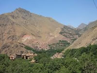 |
Atlas MountainsThe Atlas is a mountain range extending about 1,600 miles through Tunisia, Algeria, and Morocco. The Range separates the Mediterranean and Atlantic coastlines from the Sahara Desert. The highest peak in the range is called Toubkal (in Morocco), which rise 13,665 feet. |
| Back to Map | |
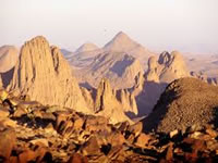 |
Hoggar MountainsThe Hoggar Mountains are a chain of rugged mountains in southern Algeria in the Sahara Desert. The highest peak is Mount Tahat, which happens to be the highest peak found in all of Algeria at 9,541 feet. At "only" two million years of age, the Hoggar Range is thought to be "new" by mountain standards. |
| Back to Map | |
 |
Grand Erg OrientalThe Grand Erg Oriental is a massive erg or field of sand dunes located mainly in Algeria and western Tunisia. To its west is the smaller (yet higher in elevation) Great Erg Occidental. Some dunes reach heights of over 500 feet tall. This desert regions does feature several oases (small cities where enough water exists to support plant life). In these cities, date palm trees are grown for commercial purposes and oil refineries help support local economies.
|
| Back to Map | |
| Population: | 38,700,000 (2014) |
| Area: | 919,595 sq. miles |
| Capital City: | Algiers |
| Largest City: | Algiers |
| Currency: | Algerian Dinar |
| Official Language: | Arabic |
| GDP (Gross Domestic Product) | $219.453 Billion |
- Algeria is the world's tenth largest country by area
- Algeria is the largest country in Africa by area
- 90% of Algeria is covered by the Sahara Desert
- Algeria has the second largest oil reserve in Africa.
- Algiers, the capital city of Algeria, was once the base of operations for the dreaded Barbary Pirates
- Algeria was conquered by France in the 1830s and was under French control until 1962.
- Giant Barbary Lions and Atlas Bears once roamed the mountain regions of Algeria, but are now extinct
- Temperatures in Algeria's desert regions can easily top 110 degrees Fahrenheit.
- Algeria's unit of currency is called dinar.
- Arabic is the official language of Algeria. |
|
 |
|
| In the Algerian flag, the white section represents peace, the green section represents Islam as does the star and crescent. The red color of the star and the crescent represent the blood of those who were killed fighting in the War for Algerian Independence, which lasted from 1954 to 1962. It was adopted as the national flag on July 3, 1962. | |